


Incident Reports
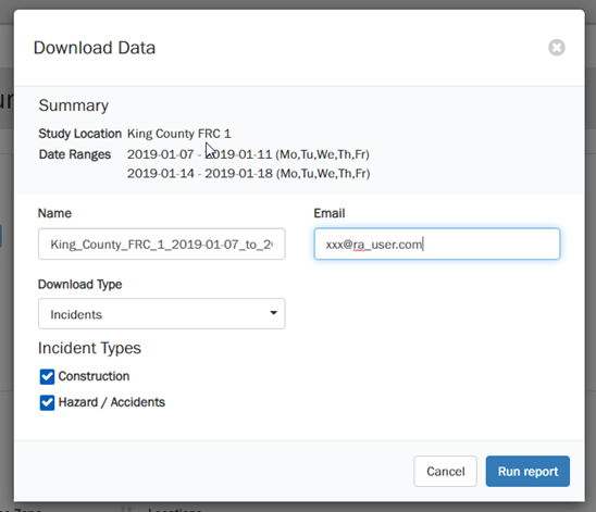
Incidents data is available in Roadway Analytics via the Data Downloader modal:
- Select ‘Incidents’ in Download Type
- Select ‘Construction’ and/or ‘Hazard/Crashes’ incident types
RA Incident Field Descriptions
| Field | Description | Notes/Examples |
|---|---|---|
| id | INRIX Incident ID | fa017d8a-35b3-46c7-9e3d-264c974ebab6 |
| severity | The severity of the incident. | Value in the range of 0-4, with 4 indicating the highest severity. 0: Minimal impact 1: Low impact 2: Moderate impact 3: High impact 4: Severe impact |
| is_road_closure | Yes or No | ‘Yes’ if the incident causes a road closure. |
| category_ids | Main Incident Category | 1: Construction 4: Crash |
| sub_category_ids | Incident Subcategories | 1: Roadworks 2: Crashes 3: Delays 4: Closures and Lane Restrictions 6: Diversions 8: Replacement Services 9: Advice 10: Incidents 18:Road Weather Precipitation Conditions 19: Road Weather Pavement Conditions 20: Road Weather Visibility Conditions 23: Incidents and Hazards 26: Other 29: Service and Timetable Changes 30: Station Closures and Restrictions 31: Operational Difficulties 36: Slip Road Incidents 37: Limited Service |
| full_description | Incident description | Example: “Right hand shoulder blocked due to crash on I-5 Northbound at WA-518.” |
| earliest_start_time_local_seen | Earliest Local Date and Time seen for the incident | Example: 2019-01-15T12:56:18-08:00 |
| latest_end_time_local_seen | Latest Local Date and Time seen for the incident | Example: 2019-01-15T13:13:48-08:00 |
| direction | Road direction impacted by the incident | ‘Both ways’, ‘Northbound’, ‘Southbound’, ‘Eastbound’, ‘Westbound’ |
| event_text | Brief Descriptions based on event codes | Example: “Crash, right Hand Shoulder Blocked” |
| location_type | Location type of the incident | location_type Location type of the incident Point, Linear, Sliproad (ramp) If location type is linear, the length column is populated to indicate the impact of the incident. |
| length | Length (Miles or KM) | Length is reported in miles or kilometers, based on user preference |
| location_dot_lat_lon | Latitude Longitude | Example: 47.664772 -122.321935 |
| bidirectional | TRUE or FALSE | TRUE if the incident impacts both sides of the road |
| segment_ids | Pipe-delimited List of XD IDs impacted by the incident | Example: 1236929345 1236929333 |
| frcs | List of Functional Road Classes (FRCs) impacted. | FRC 1 National Interstates FRC 2 Regional Highways, Expressways FRC 3 Arterials FRC 4 Collector Roads FRC 5 Local Roads |
| causes | INRIX Codes - causes | Example: 215-Recovery Work 152-Earlier Crash |
| effects | INRIX Codes - effects | Example: 833-Gore Point Obstructed 841-Left Hand Shoulder Blocked |
| infos | INRIX Codes – info | Example: 690-All lanes have been re-opened |
| alertCs | AlertC Code text | Example: 211-(Q) broken down vehicle(s) |
| schedule | For scheduled construction, days of week and local times that the construction is active. | Example: {“daysOfWeek” : [1,2,3,4,5,6,7],”fromTime”:”20:00:00”,”untilTime”:”06:00:00”} |