Overview
Dangerous Slowdowns(DSD), is a product feature under the INRIX safety alerts umbrella and is intended to offer an advance warning for back-of-queue slowdowns to allow drivers to appropriately consider a potential safety event ahead of them. The product has been developed atop the rich traffic flow dataset that INRIX uses to produce segment-level speeds.
INRIX takes real-time speeds from a segment and the upstream segment to determine if there is a greater than 35 mph delta suggesting a slowdown where drivers would need to take avoidance actions. Where a qualifying difference in speeds exists, Dangerous Slowdowns are intended to describe a point in space where severe braking starts.
Further evaluation of the qualifying difference in additional speeds after the initial location, will generate DSDs. DSD generation is dependent on real-time data densities and therefore, the prevalence of DSD may differ by geographic area, time of day, and day of the week.
Q and A on Dangerous Slowdowns:
Q: What are Dangerous Conditions?
A: Dangerous conditions can be defined as the location where cars are most likely to collide due to a rapid reduction of speed or harsh breaking.
- Back of queue on highways / limited access roads: This use case deals with identifying dangerous conditions caused by traffic jams building on the main carriageway of highways / limited access roads.
- Non Jam-related Dangerous Slowdowns: Although the dangerous condition phenomena on Highways is usually caused by a traffic jam, it can in some cases be caused by other obstructions that are causing a sudden drop in speed without causing a jam to build. Examples of such cases include hazards on the road or slowdown due to weaving at the exit from a highway.
Q: Are Dangerous Slowdowns based on real-time data?
A: Yes, DSDs will be created where neighboring spatial speeds indicate a rapid drop.
Q: Are all instances of breaking a Dangerous Slowdown?
A: No, not all areas of congestion will produce a DSD. If there is a queue where speeds gradually slow over multiple segments, this may not trigger the >35 mph minimum threshold between segments and, therefore may not trigger the creation of a DSD. In this way, DSDs differ from Congestion Alerts.
Q: What are the severity thresholds for DSD?
A: (3)35-45mph; (4)45-60mph; (5)>60mph [speed drop between segment B, and the downstream segment A]
Q: Are the alerts filterable by severity?
A: Yes, each DSD is assigned a severity based on the nature of the slowdown at the end of the queue; the severity rating is based on the speed difference between segments (see above for definitions of buckets).
Q: Where are DSD published?
A: On limited access roadways in Functional Road Classes (FRCs) 1 & 2.
Q: How long does a DSD last?
A: A DSD will last for a minimum of 2.5 minutes. It could be updated within that time, resetting that timer, if a new dangerous condition is reported within the vicinity of an existing DSD. This could result in an updated DSD, updating the version number.
Q: What does the DSD output look like?
A: See below for an example request and response.
Q: Is this an INRIX XD-only product?
A: Currently, yes.
Q: How often are DSDs calculated?
A: Once per minute
Q: Is there documentation for DSD?
A: Yes. The docs.inrix.com/traffic/dangerousslowdowns/ has onboarding documentation. Additional assistance can be provided by INRIX sales engineers.
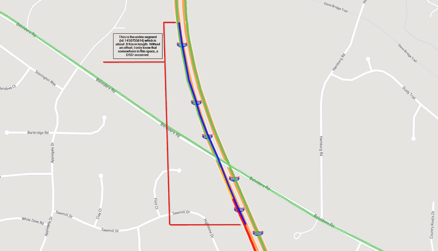
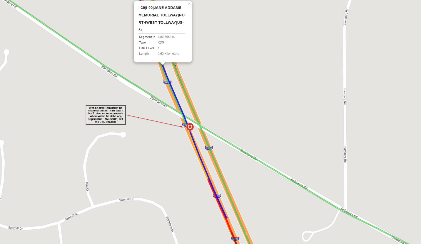
Q: With the improved spatial and temporal accuracy, how can I determine where the DSD occurred on the segment?
A: Using the offset field can help you determine where the DSD occurred. See below for an example and sample syntax.
Description: Gets Dangerous Slowdown incidents in a specified region.
dsd.api.inrix.com/v2/DangerousSlowdowns
GET Gets Dangerous Slowdown incidents in a specified region using api v2.
Parameters
= required| Name | Located In | Type | Description |
|---|---|---|---|
| accesstoken | Query | String | A valid access token provided from the GET appToken API response. Alternatively, the accesstoken can be added to the request header instead of a url parameter using format 'Authorization: Bearer xxxx.xxx.xxxx'. |
| box | Query | String | “box” specifies two latitude and longitude pairs (using the WGS 84 datum) that outline a bounding box. The first lat/long pair should be the northwestern most point, and the second pair the southeastern most point. Format- [lat1],[long1],[lat2],[long2]. Either box or point and radius parameters are required. |
| point | Query | String | Used to select a region based on a point and radius. If used, other Location parameters cannot be used. Format- [lat],[long]. Either box or point and radius or geoId parameters are required. |
| radius | Query | Double | Used to select a region based on a point and radius. If the Units parameter is set to Metric, the radius is measured in kilometers; if Units is set to US (the default), the radius is measured in miles. If used, other Location parameters cannot be used. Either box or point and radius or geoId parameters are required. |
| geoId | Query | Integer | Used to select a region based on a geography. “geoid” specifies the ID of the specified geography. For more information on how to obtain the ID, see GetGeography. When using a custom GeoId (previously created with CreateGeography), the first call will create cached files. Once these have been created the call will return the correct information. Using Geographies with a large area (e.g. countries) is not recommended. Either box or point and radius or geoId parameters are required. |
| units | Query | Integer | Use 0 for English units, 1 for metric. Default is 0. |
| accepts | Header | String | Use application/json for json format response and application/xml for xml format resposne. |
Requests
Example Get dangerous slowdowns in a box request
Queryhttps://dsd.api.inrix.com/v2/DangerousSlowdowns?box=47.62499018445947,-122.37111157170455,47.57696309936925,-122.28240319254932&accesstoken={token}
Responses
200 Success
[
  {
      "id": "abdf5c8a-5c5e-4871-9b11-c6cf739a3f5c",
      "version": 1,
      "severity": 3,
      "speedBefore": 114,
      "speedAt": 74,
      "speedDelta": 40,
      "location": {
          "geometry": {
              "coordinates": [
                  -81.78810223191056,
                  28.641491348453584
              ],
              "type": "Point"
          },
          "segment": {
              "code": "1422551945",
              "offset": 1016.60187,
              "type": "XDS"
          }
      },
      "schedule": {
          "occurrenceStartTimeUTC": "2023-03-13T14:33:38.598Z"
      },
      "description": {
          "roadName": "FLORIDA'S TPKE|RONALD REAGAN TPKE|SR-91|FLORIDA'S TPKE HOMESTEAD EXT|SR-821",
          "direction": "S",
          "mileMarker": null
      }
  }
]
Response Elements
| Property | Type | Description | ||||||||||||||||||||||||||||||||||||||||||||||||||||||||||||||||||||||||||||||||||||||||||||||||
|---|---|---|---|---|---|---|---|---|---|---|---|---|---|---|---|---|---|---|---|---|---|---|---|---|---|---|---|---|---|---|---|---|---|---|---|---|---|---|---|---|---|---|---|---|---|---|---|---|---|---|---|---|---|---|---|---|---|---|---|---|---|---|---|---|---|---|---|---|---|---|---|---|---|---|---|---|---|---|---|---|---|---|---|---|---|---|---|---|---|---|---|---|---|---|---|---|---|---|
| dangerousSlowdowns | Array | An array of Dangerous Slowdowns | ||||||||||||||||||||||||||||||||||||||||||||||||||||||||||||||||||||||||||||||||||||||||||||||||
|
||||||||||||||||||||||||||||||||||||||||||||||||||||||||||||||||||||||||||||||||||||||||||||||||||