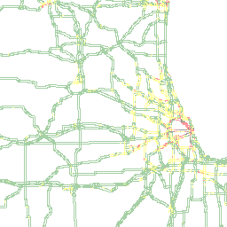
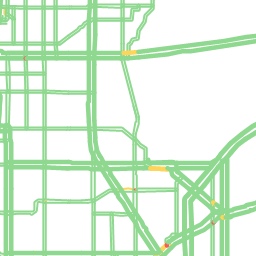
The INRIX Tile Service returns images that contain traffic graphics. They are useful for any application where maps with traffic are displayed, such as mobile and web apps.
Traffic Imagery
The INRIX Tile APIs provide convenient images to overlay on top of your own base map solution. Alternately, use the Traffic data APIs to receive just the data to build your own images. Using the Traffic APIs results in a smaller payload than tiles, but requires that you create the code to generate images, as well as data about the location and geometry of each TMC. In addition, tiles are two-dimensional, so they would not work if you plan to overlay road data on a 3D surface. The Tile Service returns images with a transparent background, so it can be superimposed over other maps, such as Google or Bing maps.
Size and Location
The size and location of the tile is specified using the Bing Maps Tile System quadkey. A Quadkey is a number made up of the digits 0-3. These represent successively smaller boxes (starting with the whole world) drilling into the location required where each smaller box is denoted by the next digit. The size of the area enclosed by a quadkey decreases with the the number of digits for the quadkey. So quadkey 01 is huge while 02123003022120 is only a square mile or so.

Speed Buckets
Speed buckets are used to determine what color is displayed on a road depending on what value the speed has as a percentage of the reference speed. You can use the default speed buckets, or you can create your own speed buckets which you specify by using the SpeedBucketId parameter. Each speed bucket contains information on the minimum and maximum percentage of reference speed in order for a speed to be contained in that bucket, as well as information for how that speed bucket is drawn, such as color, style, and width. For more information see the CreateSpeedBucket method.
Description: Generates a graphic image representation of traffic data.
tile-api.inrix.com/v1/tiles/{quadkey}?
tile-api.inrix.com/v1/tiles/{tile-coordinate}.png?
GET Generates a graphic image representation of traffic data.
Parameters
= required| Name | Located In | Type | Description | ||||||||||||||
|---|---|---|---|---|---|---|---|---|---|---|---|---|---|---|---|---|---|
| quadkey | Path | String | A Bing Maps Tile System quadkey to generate a resulting tile which represents the described area. The minimum quadkey length is 6 digits and the maximum is 19. For more information about this format, see Bing Maps Tile System. Either quadkey or tile-coordinate is required. | ||||||||||||||
| tile-coordinate | Path | String | Tile coordinates specifically identify a tile on the map at a particular zoom level. The tile-coordinate parameter is a string in the format zoom/column/row.png. For example 13/1312/2860.png. Either quadkey or tile-coordinate is required. | ||||||||||||||
| accesstoken | Query | String | A valid access token provided from the GET appToken API response. Alternatively, the accesstoken can be added to the request header instead of a url parameter using format 'Authorization: Bearer xxxx.xxx.xxxx'. | ||||||||||||||
| geoId | Query | Integer | The ID of a geography to which to crop the image. All pixels outside of the geography will be transparent. Multiple ids can be specified in a comma-delimited list. | ||||||||||||||
| opacity | Query | String | The pen opacity, as a percentage value between 0 and 100. The default is 100. | ||||||||||||||
| penWidth | Query | Float | The pen width of the traffic overlay, in pixels. The default is 4. | ||||||||||||||
| FRCLevel | Query | String | The Functional Road Classification code of the road segments to report. Multiple codes can be specified in a comma-delimited list. | ||||||||||||||
|
|||||||||||||||||
| startTime | Query | Datetime | This parameter is an optional date/time field in UTC, used to show predicted traffic, i.e. a number of minutes into the future from now. An example timestamp would be 2017-08-06T16:04:00Z | ||||||||||||||
| roadSegmentType | Query | String | The Road Segment Type (Location Referencing method) for the traffic tile to be returned. | ||||||||||||||
|
|||||||||||||||||
Requests
Example Tiles Request
Queryhttp://tile-api.inrix.com/v1/tiles/0302222?roadsegmenttype=XDS&opacity=40&FRCLevel=1,2&penWidth=3&accessToken={token}
Responses
200 Success