What Data Does INRIX TPEG Provide?
Types of Data
The TPEG Service provides the following types of data:
- TFP — Traffic Flow and Prediction, which refers to the state of traffic at various locations, both in the present moment and predictions for the future.
- TEC — Traffic Event Compact, which refers to incidents that may affect traffic.
- PKI — Parking information.
The TPEG standard also includes fuel information (FPI) and weather information (WEA), but these are not currently served by INRIX.
TFP
Traffic Flow and Prediction data describes how traffic is flowing at the current time, as well as what is predicted for the near future.
How Locations Are Specified
Locations are primarily specified through TMCs, which are a standard way of specifying road segments. However, not all roads are included in the TMC tables, and for many TMCs, it is useful to divide them into smaller segments. Therefore, in addition to TMCs, the TPEG service uses:
- Sub-TMCs, which are segments within a TMC.
- Off-TMCs, which are road segments that are not included in standard TMC tables.
By using sub-TMCs, the TPEG service is able to provide traffic information at higher resolution. The resolution is specified at either 10m or 100m sections of road. Examples of off-TMCs include:
- Rural roads
- New roads, which have not yet been added to the tables
- Road segments, such as highway on-ramps, that are too small to be included in TMC tables
For off-TMCs, location is specified by AGORA-C (DLR-1). AGORA-C specifies a method for dynamic encoding and decoding of location references into any map, without requiring predefined location codes or lookup tables. AGORA-C provides latitude and longitude data for roads, along with direction.
Level of Service
Traffic flow is described with a Level of Service (LOS) value. This is usually the most important piece of traffic information, since it tells users how fast traffic is moving on a given piece of road. Often LOS values are translated into colors (for example, green for free-flowing, yellow for slow-moving, and red for stop-and-go) and overlayed onto maps. The LOS value is determined by comparing the speed on a TMC (either current or predicted) with the reference speed, which is typically the speed limit. The speed is divided by the reference speed, and then the LOS value is determined from the value as a percentage. For example, if a TMC has a reference speed of 60 miles per hour, but the speed on the road is measured at 20 miles per hour, then the speed would be 33% of reference speed, which would typically correspond to an LOS value of 5. See the Level of Service glossary entry for sample Level of Service values, meanings, and colors you could use in your user interface.
Location Referencing
INRIX uses location referencing to reduce the amount of data returned by only sending changes to the Level of Service (LOS) within a linear. In order to minimize the amount of data transmitted, TFP data for a linear is sent using the following information:
- Starting TMC
- The LOS (Level of Service) for that TMC
- The number of TMCs for which that LOS applies
If the next TMC in the series has a different LOS value, then the pattern is repeated, where the TMC with the new value is the starting TMC, followed by its LOS value and the number of TMCs that have the same value. Since LOS’s are often the same for contiguous TMCs, this is a very efficient way to package the data. The following example shows TMCs in a linear:
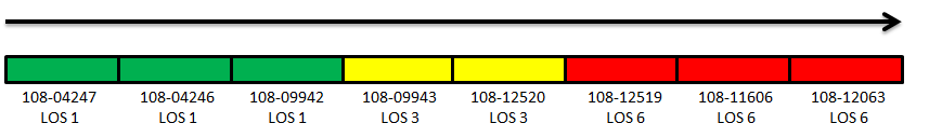
In this example, there are three TMC segments with LOS 1, followed by two with LOS 3, followed by three with LOS 7. So the TPEG data would take the form:
- TMC108-04247, LOS 1, 3
- TMC108-09943, LOS 3, 2
- TMC108-12519, LOS 6, 3
Note: This technique is only used for one direction at a time.
Note: Sub-TMCs are handled in a very similar way, except that instead of TMCs in a linear, it works with sub-TMCs in a TMC.
Prediction
For traffic flow prediction, TFP data is grouped into time slices. For example, all of the TFP data for the current traffic situation is grouped together, and there can be another similar grouping for data predicted for 15 minutes into the future, and another for data predicted for 30 minutes into the future. Note: INRIX TPEG Connect provides traffic prediction, even though it is not part of the TISA TPEG standard.
TEC
Traffic incidents are included in the TPEG data if they are relevant to the vehicle’s position, route, or destination. Information about the event includes:
- A code for the type of incident
- The length of road that is affected
- Traffic speed at the incident
- Estimated delay
- Location of the TMC that contains the incident
- Incident location within the TMC as an offset
- Direction information
Previous: In What Format Is Data Provided? |
Next: Additional TPEG Resources |