INRIX Safety Alerts return information about many different type of incidents that happen on roadways that can impact people and businesses in different ways. INRIX classifies the incident types for better filtering, identifies where it is, when it is, and details such as the severity of the impact.
Overview
- Crashes and Hazards (Incident Type 4)
- Events (Incident Type 2)
- Construction (Incident Type 1)
- Congestion alerts (Incident Type 3). Also known as Flow incidents.
The main usage scenarios are:
- Displaying incidents on a map
- Creating routes that avoid incidents
- Creating alerts for upcoming incidents
- Real Time Rerouting - leveraging the data to support routing around severe incidents
- Route Planning - leveraging planned incidents to avoid closures and other severe occurances
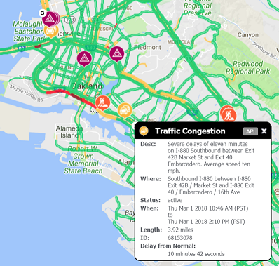
Example Application
The following image is a screen-shot from a sample traffic application that shows incidents. When an incident is selected, details about it are dislayed.
Description: Retrieves traffic-related incidents in a specified region.
incident-api.inrix.com/v1/incidents
GET Get traffic related incident data in a specified region.
Parameters
= required= use only one of these parameters to specify the geographic location you are querying. With the exception of point and radius which should be used as a pair (must specify both).
| Name | Located In | Type | Description | ||||||||||||||||||||||||||||
|---|---|---|---|---|---|---|---|---|---|---|---|---|---|---|---|---|---|---|---|---|---|---|---|---|---|---|---|---|---|---|---|
| Authorization | Header | String | A valid bearer access token provided from the GET appToken API response. The token must be added to the request header using the format 'Authorization: Bearer xxxx.xxx.xxxx'. | ||||||||||||||||||||||||||||
| box | Query | String | “box” specifies two latitude and longitude pairs (using the WGS 84 datum) that outline a bounding box. The first lat/long pair should be the northwestern most point, and the second pair the southeastern most point. Format- [lat1]|[long1],[lat2]|[long2]. There is a limit of 10 degrees between the minimum and maximum latitude and longitude values you can specify. If used, other Location parameters cannot be used. Either box, point and radius, geoId or ids parameters are required. | ||||||||||||||||||||||||||||
| point | Query | String | Used to select a region based on a point and radius. If used, other Location parameters cannot be used. Format- [lat]|[long]. If used, other Location parameters cannot be used. Either box, point and radius, geoId or ids parameters are required. | ||||||||||||||||||||||||||||
| radius | Query | Double | Used to select a region based on a point and radius. If the Units parameter is set to Metric, the radius is measured in kilometers; if Units is set to US (the default), the radius is measured in miles. The maximum radius you can specify is 500 miles (804 kilometers). If used, other Location parameters cannot be used. Either box, point and radius, geoId or ids parameters are required. | ||||||||||||||||||||||||||||
| geoId | Query | Integer | Used to select a region based on a geography. “geoid” specifies the ID of the specified geography. For more information on how to obtain the ID, see GetGeography. If used, other Location parameters cannot be used. Either box, point and radius, geoId or ids parameters are required. | ||||||||||||||||||||||||||||
| ids | Query | String | One or more incident IDs in a comma-delimited list. The maximum number of IDs you can list in a single request is 1000. If used, other Location parameters cannot be used. Either box, point and radius, geoId or ids parameters are required. | ||||||||||||||||||||||||||||
| incidentoutputfields | Query | String | The incident fields to output. Multiple fields can be specified in a comma-delimited list. | ||||||||||||||||||||||||||||
|
|||||||||||||||||||||||||||||||
| incidenttype | Query | String | The types of incidents to output. Multiple incident types can be specified in a comma-delimited list. The default is “Incidents,Construction,Events,Flow.”. Note, the first letter of each option can also be used. For example “I,C,E,F” also will work. | ||||||||||||||||||||||||||||
|
|||||||||||||||||||||||||||||||
| severity | Query | String | Filters incident reports based on severity level. This value can be in the range of 0-4, with 4 indicating the highest severity. Multiple severity values can be specified in a comma-delimited list. You can specify all severity values by not including this parameter or by using an empty value. | ||||||||||||||||||||||||||||
| units | Query | Integer | Use 0 for English units, 1 for metric. Default is 0. | ||||||||||||||||||||||||||||
| status | Query | String | The status of the incident. Possible values are Active, Cleared, Inactive or All. Default is All. | ||||||||||||||||||||||||||||
| advancewarning | Query | Boolean | If the incidents returned should be limited to only ones which require advanced warning. Default if no value provided is to return both incidents which have advance working and those which do not. . | ||||||||||||||||||||||||||||
| starttime | Query | Datetime | The incidents for this future time. The default is the current time. All times should be in UTC or have the timezone offset as specified in DateTime Values and be specified using the ISO 8601 format. | ||||||||||||||||||||||||||||
| minDelayFreeFlowMinutes | Query | Integer | Filters out incidents with a FreeFlowMinutes delay less than the value set. | ||||||||||||||||||||||||||||
| minFromTypicalFlowMinutes | Query | Integer | Filters out incidents with a FreeFlowMinutes delay less than the value set. | ||||||||||||||||||||||||||||
| minDelayDistance | Query | Integer | Filters out incidents with a delayDistance value less than the value set. | ||||||||||||||||||||||||||||
| roadSegmentType | Query | String | The location reference method used for the incidents. Supported values are TMC, XDS (default) or OSM. | ||||||||||||||||||||||||||||
| locale | Query | String | The language for description text. US English is the default locale. Specifying locale=local will return the default language for this region. For further information, see Incident Locales. | ||||||||||||||||||||||||||||
Requests
Example Get Incidents request
Queryhttps://incident-api.inrix.com/v1/incidents?box=47.67577|-122.207249,47.743362|-122.16227&incidentType=Incidents,Flow,Construction&incidentoutputfields=all
Responses
200 Success
{
    "copyright": "Copyright INRIX Inc. 2021",
    "createdDate": "2021-11-22T23:30:20.1473897Z",
    "responseId": "1878b04e-8771-4b17-a6e7-a768060e5120",
    "versionNumber": "v1",
    "result": {
        "incidents": [
            {
                "id": 148193245,
                "version": "1",
                "type": "1",
                "severity": "0",
                "geometry": {
                    "type": "Point",
                    "coordinates": [
                        -122.1757,
                        47.70814
                    ]
                },
                "status": "active",
                "messages": {
                    "alertCMessageCodes": [
                        {
                            "eventCode": "701",
                            "level": "Primary",
                            "quantifierType": "0"
                        },
                        {
                            "eventCode": "701",
                            "level": "Secondary",
                            "quantifierType": "0"
                        }
                    ],
                    "inrixMessage": [
                        {
                            "inrixCode": "701",
                            "type": "Effect"
                        },
                        {
                            "inrixCode": "1",
                            "type": "Cause"
                        }
                    ]
                },
                "location": {
                    "countryCode": "1",
                    "direction": "both ways",
                    "biDirectional": "true",
                    "segments": [
                        {
                            "type": "XDS",
                            "offset": "796,797",
                            "code": "1237057273"
                        },
                        {
                            "type": "XDS",
                            "offset": "0,406",
                            "code": "1236913499"
                        },
                        {
                            "type": "XDS",
                            "offset": "0,54",
                            "code": "440930544"
                        }
                    ],
                    "oppositeSegments": [
                        {
                            "type": "XDS",
                            "offset": "80,136",
                            "code": "440930541"
                        },
                        {
                            "type": "XDS",
                            "offset": "0,406",
                            "code": "1236913540"
                        }
                    ]
                },
                "schedule": {
                    "planned": "true",
                    "advanceWarning": "false",
                    "occurrenceStartTime": "2021-05-28T07:01:00Z",
                    "occurrenceEndTime": "2022-01-01T07:59:00Z",
                    "descriptions": {
                        "lang": "en-US",
                        "desc": "Starts at 5/28/2021 12:01 AM, ends at 12/31/2021 11:59 PM."
                    }
                },
                "descriptions": [
                    {
                        "type": "short",
                        "lang": "en-US",
                        "desc": "124th Ave: intermittent lane closures from 116th St to NE 124th Ave"
                    },
                    {
                        "type": "long",
                        "lang": "en-US",
                        "desc": "Intermittent lane closures due to construction on 124th Ave both ways from 116th St to NE 124th Ave."
                    },
                    {
                        "type": "Text-to-Speech",
                        "lang": "en-US",
                        "desc": "On 124th Avenue both ways, from 116th Street, to NE 124th Avenue, there are intermittent lane closures because of construction."
                    }
                ],
                "parameterizedDescription": {
                    "eventCode": "701",
                    "eventText": "Intermittent Lane Closures, construction",
                    "roadName": "124th Ave",
                    "direction": "both ways",
                    "crossroad1": "116th St / 124th Ave",
                    "crossroad2": "NE 124th Ave",
                    "position1": "from",
                    "position2": "to"
                },
                "head": {
                    "geometry": {
                        "type": "Point",
                        "coordinates": [
                            -122.1757,
                            47.70814
                        ]
                    }
                },
                "tail": [
                    {
                        "geometry": {
                            "type": "Point",
                            "coordinates": [
                                -122.1758,
                                47.70399
                            ]
                        }
                    }
                ],
                "rds": {
                    "alertcMessage": "00CABD2424004957A000000000000000000000000000000000",
                    "direction": "1",
                    "extent": "1",
                    "duration": "121445",
                    "diversion": "false",
                    "directionalityChanged": "false",
                    "eventCode": [
                        {
                            "code": "701",
                            "primary": "true"
                        },
                        {
                            "code": "701",
                            "primary": "false"
                        }
                    ]
                }
            }
        ]
    }
}
Response Elements
| Property | Type | Description | ||||||||||||||||||||||||||||||||||||||||||||||||||||||||||||||||||||||||||||||||||||||||||||||||||||||||||||||||||||||||||||||||||||||||||||||||||||||||||||||||||||||||||||||||||||||||||||||||||||||||||||||||||||||||||||||||||||||||||||||||||||||||||||||||||||||||||||||||||||||||||||||||||||||||||||||||||||||||||||||||||||||||||||||||||||||||||||
|---|---|---|---|---|---|---|---|---|---|---|---|---|---|---|---|---|---|---|---|---|---|---|---|---|---|---|---|---|---|---|---|---|---|---|---|---|---|---|---|---|---|---|---|---|---|---|---|---|---|---|---|---|---|---|---|---|---|---|---|---|---|---|---|---|---|---|---|---|---|---|---|---|---|---|---|---|---|---|---|---|---|---|---|---|---|---|---|---|---|---|---|---|---|---|---|---|---|---|---|---|---|---|---|---|---|---|---|---|---|---|---|---|---|---|---|---|---|---|---|---|---|---|---|---|---|---|---|---|---|---|---|---|---|---|---|---|---|---|---|---|---|---|---|---|---|---|---|---|---|---|---|---|---|---|---|---|---|---|---|---|---|---|---|---|---|---|---|---|---|---|---|---|---|---|---|---|---|---|---|---|---|---|---|---|---|---|---|---|---|---|---|---|---|---|---|---|---|---|---|---|---|---|---|---|---|---|---|---|---|---|---|---|---|---|---|---|---|---|---|---|---|---|---|---|---|---|---|---|---|---|---|---|---|---|---|---|---|---|---|---|---|---|---|---|---|---|---|---|---|---|---|---|---|---|---|---|---|---|---|---|---|---|---|---|---|---|---|---|---|---|---|---|---|---|---|---|---|---|---|---|---|---|---|---|---|---|---|---|---|---|---|---|---|---|---|---|---|---|---|---|---|---|---|---|---|---|---|---|---|---|---|---|---|---|---|---|---|---|---|---|---|---|---|---|---|---|---|---|---|---|---|---|---|---|---|---|---|---|---|---|---|---|---|---|---|---|---|---|---|---|
| Incidents | Array | A collection of Incident elements | ||||||||||||||||||||||||||||||||||||||||||||||||||||||||||||||||||||||||||||||||||||||||||||||||||||||||||||||||||||||||||||||||||||||||||||||||||||||||||||||||||||||||||||||||||||||||||||||||||||||||||||||||||||||||||||||||||||||||||||||||||||||||||||||||||||||||||||||||||||||||||||||||||||||||||||||||||||||||||||||||||||||||||||||||||||||||||||
|
||||||||||||||||||||||||||||||||||||||||||||||||||||||||||||||||||||||||||||||||||||||||||||||||||||||||||||||||||||||||||||||||||||||||||||||||||||||||||||||||||||||||||||||||||||||||||||||||||||||||||||||||||||||||||||||||||||||||||||||||||||||||||||||||||||||||||||||||||||||||||||||||||||||||||||||||||||||||||||||||||||||||||||||||||||||||||||||