The INRIX Incident Service provides information on incidents that can impact traffic, including:
Overview
Crashes and Hazards (Incident Type 4)
Events (Incident Type 2)
Construction (Incident Type 1)
Congestion alerts (Incident Type 3)
The main usage scenarios are:
Displaying incidents on a map
Creating routes that avoid incidents
Creating alerts for upcoming incidents
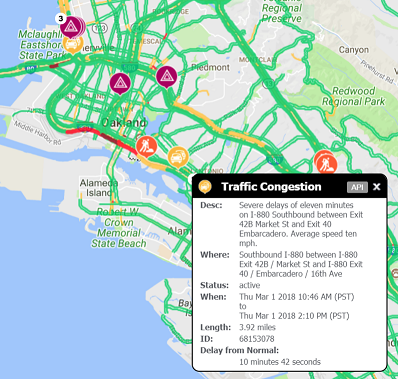
Example Application
The following image is a screen-shot from a sample traffic application that shows incidents. When an incident is selected, details about it are dislayed.
FAQs
What types of incidents you have?
There are two types of incidents: curated incidents (crashes, hazards, construction, events) and calculated incidents (flow/congestion incidents). Curated incidents are from sources such as DOTs, twitter feeds, police scanners and other sources and are managed by the INRIX incident group.
Calculated incidents (i.e. our flow incidents) are a type of incident that is calculated at INRIX and compares real-time speeds with free flow speeds in order to allow for an understanding of abnormal conditions. Here is a case study of how PennDOT is utilizing these flow incidents: https://inrix.com/blog/2019/11/pennsylvania-dot-study-highlights-how-crowdsourced-data-can-be-a-game-changer/
Do you have historical incidents available?
Yes - we have a historical incident product line that is provided through http://analytics.inrix.com. This includes Construction/Crash/Hazard incidents back to August 2016. Our Flow incidents are additionally provided through the historical bottleneck tool also located at http://analytics.inrix.com. If you would like trial access to roadway analytics, please sign up here: http://www2.inrix.com/trial-roadway-analytics
What is the latency for getting a road closure or other map incidents in the Inrix system?
We can typically get a road closure or other map incident in the INRIX system within 2-3 minutes of a closure althought there are cases where it can take longer.
What does Inactive incident status mean?
An inactive incident is an incident that is not currently happening, but is expected to be at some point. For example, construction which happens overnight, every night, long-term construction lifted for the holidays, etc.
What are congestion incidents?
Congestion Incidents (also called flow incidents or XDFI) are representations of abnormally queuing traffic (that is, worse than NAS) which are concatenated into incident objects - each congestion incident representing one queue, to the extent that that is ontologically possible. Congestion incidents will always be of “Type=3” in the XD Incidents API output. They contain only queue-based information (length, speed, tendency, delay). A congestion incident will never contain cause or effect information such as “crash”, “lane closed” etc.
Is there a way to show Congestion incidents that are not repeating?
We provide flow data with indicators of ‘fromTypicalFlowMinutes’ as well as ‘fromFreeFlowMinutes’. Both of these are indicators of how severe the congestion incident is. You can additionally utilize filters like ‘minFromTypicalFlowMinutes’ which allows you to only see congestion incidents of a certain severity.
For example, if you are seeing repeated congestion that you would expect everyday, then applying a ‘minFromTypicalFlowMinutes’ filter should only return flow incidents that are atypical.
How are severity levels for flow incidents set?
With a two-factor algorithm which takes the delay in minutes over NAS and the road class into account. See chart below where for example a delay of between 500 and 900 seconds on a FRC 1 road is a severity 2:
Delay (Seconds)
FRC 1
FRC 2
FRC 3
FRC 4
FRC 5
< 180
-
-
-
-
-
180 +
1
1
0
0
0
300 +
2
1
0
0
0
600 +
2
2
1
1
0
900 +
3
2
2
1
1
When is status considered “active” versus “cleared” for congestion? It seems like incidents within the same version are considered active, cleared, and inactive. When do these get triggered as active or inactive?
There will be times when a congestion incident can go from active to cleared and then back to active. If there is an incident that meets our criteria for being cleared, but then another congestion incident shows up that is similar enough to the previous flocongestionw incident, we will give it the same ID and mark it as active.
Will a congestion incident ever be considered “inactive”?
There are no cases of congestion incidents being output in Inactive. Congestion incidents are output as “cleared” for 30 minutes after they have ended (ie, when traffic has returned to normal), as is the case with other incidents.
How do I identify the amount of time of each incident version was valid?
The length of time that each version of a congestion incident by using the LastUpdated field. So the lifespan of version n is: LastUpdated of version n+1 minus LastUpdated of version n.
So for example, incident 113374983 :
Version 1, LastUpdated 2019-07-31T13:22:34.256365Z
Version 2, LastUpdated 2019-07-31T13:27:42.0822358Z
Version 3, LastUpdated 2019-07-31T13:36:34.5505373Z
Version 4, LastUpdated 2019-07-31T13:37:43.781517Z
Version 5, LastUpdated 2019-07-31T13:41:37.9177832Z
Version 6 (CLEARED), LastUpdated 2019-07-31T13:46:28.2832673Z
o the lifespan of version 1 was 5 minutes and 8 seconds, and that of version 2 was 8 minutes and 52 seconds,etc. Version 6 doesn’t have a meaningful lifespan as it is a cleared incident.
Description: Retrieves XD traffic-related incidents in a specified region.
/?Action=GetXDIncidentsinBox
GETGet traffic related incident data for specified rectangular region.
Parameters
= required
Name
Located In
Type
Description
action
Query
String
Use getXDIncidentsinBox
token
Query
String
A valid authorization token returned in response to a GetSecurityToken request.
corner1
Path
String
The first corner of the region in which to get data. This parameter must be specified as a pair of latitude and longitude values separated by a pipe character (|), in the form Corner1=latitude|longitude. The latitude and longitude values are expressed using the WGS 84 datum. Northern latitudes are positive and southern latitudes are negative. Eastern hemisphere longitudes are positive and western hemisphere longitudes are negative. Longitudes in North America are negative. The corner specified by the Corner1 parameter can be any of the four corners of the bounding rectangle.
corner2
Path
String
The second corner of the region in which to get data. The Corner2 parameter is the geometric opposite of Corner1.
incidentoutputfields
Query
String
The incident fields to output. Multiple fields can be specified in a comma-delimited list. The default is the primary incident element attributes, short and long description, TMCs and Parameterized description.
Value
Description
All
This option returns all of the options available including new fields added in the future. If this is requested, the requesting system should be designed in anticipation of new fields being returned in the future.
ID
The unique identifier of an incident.
Version
The version number of the incident report, incremented each time an incident report is updated.
Type
The type of the incident (Incidents, Construction, Events, Flow, or Area). Incidents can be determined from the Alert-C event code, Construction indicates the presence of road construction, Events can be weather-related or a scheduled sporting/public event, and Flow indicates a blocking incident.
Severity
The severity of the incident. This value can be in the range of 0-4, with 4 indicating the highest severity.
EventCode
The event code of the incident. These are standard Alert-C event codes.
LatLong
The latitude and longitude of the incident.
Impacting
Whether the incident impacts traffic flow. This field is set to “yes” if the appearance of the incident changes the traffic flow below a certain percentage from that which is normally expected for the given segment of road at that time, given the current conditions.
StartTime
The starting time of the incident.
EndTime
The ending time of the incident.
DelayImpact
Provide the delay in minutes versus typical conditions and versus free flow conditions.
Area
The points in a polygon that describes an incident that is returned, in GML format. For more information about GML format, see http://www.opengeospatial.org/standards/gml.
TMCs
The list of TMC segments affected by this incident.
ParameterizedDescription
The description separated into parameters.
RDS
The Radio Data System data. See the RDS element for more information.
ShortDescription
Short textual description of the incident including language code.
FullDescription
Longer textual description of the incident including language code.
TTSDescription
The incident is described as if a human were reading the incident.
HeadTail
The location of the start and end of the incident.
incidenttype
Query
String
The types of incidents to output. Multiple incident types can be specified in a comma-delimited list. The default is “Incidents,Construction,Events,Flow.”. Note, the first letter of each option can also be used. For example “I,C,E,R” also will work.
Value
Description
Incidents
This option returns all unusual incidents that may slow down traffic such as a car accident.
Construction
This option returns only construction incidents.
Events
This option returns unusual events slated for the area such as a major sporting event.
Flow
This option returns reports about the slowing down of traffic on your route.
incidentsource
Query
String
A value of “INRIXonly” specifies that incidents are compiled from non-commercial sources, such as flow incidents that are generated programmatically from Inrix traffic information or planned construction incidents. A value of “Community” specifies that incidents come from community sources, such as incidents submitted through mobile devices. The default is INRIXonly.
Value
Description
INRIXonly
Return incidents from non-commercial sources.
Community
Return incidents from community sources.
severity
Query
String
Filters incident reports based on severity level. This value can be in the range of 0-4, with 4 indicating the highest severity. Multiple severity values can be specified in a comma-delimited list. You can specify all severity values by not including this parameter or by using an empty value.
units
Query
Integer
Use 0 for English units, 1 for metric. Default is 0.
status
Query
String
The status of the incident. Possible values are Active, Cleared, Inactive or All. Default is All.
advancewarning
Query
Boolean
If the incidents returned should be limited to only ones which require advanced warning. Default is true.
Format
Query
String
The format of the response in either XML or JSON. Default is XML.
starttime
Query
Datetime
The incidents for this future time. The default is the current time. All times should be in UTC or have the timezone offset as specified in DateTime Values and be specified using the ISO 8601 format.
minDelayFreeFlowMinutes
Query
Integer
Filters out incidents with a FreeFlowMinutes delay less than the value set.
minFromTypicalFlowMinutes
Query
Integer
Filters out incidents with a FreeFlowMinutes delay less than the value set.
minDelayDistance
Query
Integer
Filters out incidents with a delayDistance value less than the value set.
locRefMethod
Query
String
The location reference method returned for the incidents. Supported values are TMC (default), TMC11 or XD. Multiple values can be submitted separated by commas. Specifying TMC11 will return the normal 9 character TMCs with a 2 letter ISO country code which is needed because in some cases, the 9 digit TMCs are duplicated between countries. Using the TMC11 clarifies this duplication.
locale
Query
String
The language for description text. US English is the default locale. Specifying locale=local will return the default language for this region. For further information, see Incident Locales.
{"docType":"GetXDIncidentsInBox","copyright":"Copyright INRIX Inc.","versionNumber":"11.2","createdDate":"2018-01-18T01:25:49Z","statusId":0,"statusText":"OK","responseId":"00034875-6db5-4a6c-a654-360a95911bd3","result":{"XDIncidents":[{"id":60725077,"version":"2","type":"1","severity":"2","geometry":{"type":"point","coordinates":["30.273200","-97.738239"]},"impacting":"Y","status":"inactive","messages":{"alertCMessageCodes":[{"eventCode":"401","level":"Primary"},{"eventCode":"703","level":"Secondary","quantifierType":"0"}],"inrixMessage":[{"inrixCode":"8","type":"Effect"},{"inrixCode":"219","type":"Cause","quantifierData":"the 3M Half Marathon","quantifierType":"description"}]},"location":{"countryCode":"1","direction":"Southbound","biDirectional":"false","segments":[{"type":"XDS","offset":"106,339","code":"1595252338"},{"type":"XDS","offset":"0,10","code":"1595252326"}]},"schedule":{"planned":"true","advanceWarning":"false","occurrenceStartTime":"2018-01-20T13:00:00Z","occurrenceEndTime":"2018-01-22T00:00:00Z","descriptions":{"lang":"en-US","desc":"Starts at 1/20/2018 7:00 AM, ends at 1/21/2018 6:00 PM."}},"descriptions":[{"type":"short","lang":"en-US","desc":"San Jacinto Blvd S/B: road closed from 14th St to 12th St"},{"type":"long","lang":"en-US","desc":"Road closed due to the 3M Half Marathon on San Jacinto Blvd Southbound from 14th St to 12th St."},{"type":"Text-to-Speech","lang":"en-US","desc":"San Jacinto Boulevard Southbound is closed because of the 3M Half Marathon from 14th Street to 12th Street."}],"parameterizedDescription":{"eventCode":"401","eventText":"Road closed, other","roadName":"San Jacinto Blvd","direction":"Southbound","crossroad1":"14th St / San Jacinto Blvd","crossroad2":"San Jacinto Blvd / 12th St","position1":"from","position2":"to"},"head":{"geometry":{"type":"point","coordinates":["30.273200","-97.738239"]}},"tail":[{"geometry":{"type":"point","coordinates":["30.275270","-97.737464"]}}],"lastDetourPoints":[{"geometry":{"type":"point","coordinates":["30.276282","-97.737100"]}}],"dlrs":{"type":"XDSegment","segments":[{"id":"1595252338","offset":"106,339"},{"id":"1595252326","offset":"0,10"}]},"rds":{"alertcMessage":"0089913484004957E000000000000000000000000000000000","direction":"0","extent":"1","duration":"6069","diversion":"false","directionalityChanged":"false","eventCode":[{"code":"401","primary":"true"},{"code":"703","primary":"false"}]},"delayImpact":{"fromTypicalMinutes":"0.00","fromFreeFlowMinutes":"0.12","distance":"0.24","abnormal":"false"}}}]}
Response Elements
Property
Type
Description
XDIncidents
Array
A collection of XD Incident elements
Property
Type
Description
id
String
The unique identifier associated with the incident
version
String
The version of the incident report
type
Unsigned byte
The type of incident: 1=Construction, 2=Event, 3=Flow, 4=Incident
severity
Integer
The severity of the incident. This value can be in the range of 0-4, with 4 indicating the highest severity. 0 – Minimal impact 1 – Low impact 2 – Moderate impact 3 – High impact 4 – Severe impact
geometry
Geojson point
The longitude and latitude of the incident
impacting
Boolean
Indicates if the incident is impacting traffic
status
String
Whether the incident is active, cleared or inactive.
endTime
Datetime
Indicates when the incident ends
messages
Array
AlertC and INRIX codes describing the cause or effect of the incident.
Property
Type
Description
alertCMessageCodes
Array
AlertC codes describing the cause or effect of the incident.
Property
Type
Description
eventCode
Integer
AlertC codes describing the cause or effect of the incident.
level
String
“Primary”, “Secondary” or “Supplemental”
quantifierType
Integer
Optional AlertC quantifier. See the AlertC specifications for more details.
inrixMessage
Array
INRIX cause / effect incident codes of the incident.
Property
Type
Description
inrixcode
Integer
INRIX codes describing the cause or effect of the incident.
type
String
“Cause”, “Effect” or “Information”
quantifierType
String
Optional AlertC quantifier. See the AlertC specifications for more details.
quantifierData
String
Data related to the Quantifier Type.
location
Array
Location of the incident based on the TMC or INRIX XD segment.
Property
Type
Description
countryCode
String
0, 1, C
direction
String
The direction of the issue (e.g. “Both ways”, “Northbound”, “Eastbound”).
biDirectional
String
If the issue affects both directions of the roadway. "true" or "false".
segments
Array
TMC or XD segment plus optional offset information.
Property
Type
Description
type
String
Indicates type of segment. Possible values are “TMC” and “XDS”. XDS refers to a segment type of INRIX XD segment.
code
String
Unique identifier for the segment. The value would be the TMC code or the INRIX XD Segment ID.
offset
Integer, integer
Start and end offset on the segment in meters
schedule
Array
Schedule of incident including start and end times and recurring schedule if applicable.
Property
Type
Description
planned
String
“true” if this is a planned incident, or “false” if it isn’t planned.
advanceWarning
String
occurrenceStartTime
String
UTC time when the incident began, or when the next occurrence is expected to start.
occurrenceEndTime
Array
UTC time when the incident is expected to end, or when the next occurrence is expected to end.
occurrenceEndTime
Array
UTC time when the incident is expected to end, or when the next occurrence is expected to end.
reoccurring
Array
If this incident is reoccurring this element describes when it will reoccur. “DaysOfWeek” describes which days the incident will reoccur. “From” and “Until” detail the start and end times of the occurrence.
Property
Type
Description
daysOfWeek
String
which days the incident will reoccur.
from
String
start times of the occurrence.
until
String
End times of the occurrence.
startTime
String
UTC time when this incident first began. Only used for reoccurring incidents.
endTime
String
UTC time of the final incident reoccurrence. Only used for reoccurring incidents.
description
Array
Textual description of the incident start and end(s)
Property
Type
Description
desc
String
Description of the start and end in specific language.
lang
String
Language code for the description
descriptions
Array
Textual descriptions of the incident.
Property
Type
Description
type
String
Short, long or text-to-speech. The text-to-speech description is designed to be spoken to the customer. Each description is in the language specified with the Locale input parameter.
desc
String
Description of the incident in specific language for each type of description.
lang
String
Language code for the description
parameterizedDescription
Array
Provides information on a type of traffic event associated with an event code.
Property
Type
Description
crossroad1
String
Name and TMC of the crossroad where the event occurs
crossroad2
String
Name and TMC of the crossroad where the event occurs
direction
String
Direction of travel on road for which event occurs
eventCode
String
Identifies the type of event
eventText
String
Textual description of the type of event
fromLocation
String
The city that the road is going from.
position1
String
Positional relationship between RoadName and Crossroad1
position2
String
Positional relationship between RoadName and Crossroad2
roadName
String
Name of the road or venue where the event occurs
toLocation
String
The city that the road is going towards.
head
Geojson point
Location of the furthest point on the road where the incident starts.
tails
Geojson point
Location of the furthest point on the road where the incident ends.
lastDetourPoints
Geojson point
Location of the last detour point to avoid the incident.
dlrs
Array
List of INRIX segmentIds the incident is located on.
Property
Type
Description
type
String
Either XDSegment or TMC
segments
Array
SegmentIds
Property
Type
Description
id
String
Unique identifier for the segment. The value would be the TMC code or the INRIX XD Segment ID.
offset
Integer, integer
Start and end offset on the segment in meters
rds
Array
Radio Data System data.
Property
Type
Description
alertcMessage
Hexadecimal
Alert C encoded message that contains the incident information.
tmcLocation
Integer
TMC location code that represents an intersection
tmcCountry
Integer
Country code for the TMC. 0 indicates United States and 1 indicates United Kingdom.
tmcRegion
Integer
Region code for the TMC. There are multiple regions per country.
direction
Integer
Direction of queue growth. 0 indicates queue growth is positive, and flow growth is negative. 1 means queue growth is negative and flow growth is positive.
extent
Integer
Number of TMC paths affected by this incident. If 0, then just this TMC is affected; if 1, then the incident also affects the adjacent TMC paths; and so on.
duration
Integer
Expected remaining duration of the incident, in minutes. This value is often just an estimate. When encoded, the duration value is often set to zero, meaning unknown.
diversion
Boolean
Whether or not drivers are recommended to avoid the area if possible. 0 indicates avoiding is not recommended and 1 indicates avoiding is recommended.
directionalityChanged
Boolean
Whether the directionality is different than the default event code directionality. See Notes.
eventCode
Array
Represents a Radio Data System Alert C event code
Property
Type
Description
value
Integer
EventCode value, as described in document ISO/FDIS 14819-2.
primary
Boolean
If there are multiple event codes, this indicates whether this is the primary event code.
delayImpact
Geojson point
Location of the last detour point to avoid the incident.
Property
Type
Description
fromTypicalMinutes
Double
The increase in travel time across the road extent affected by the incident relative to the travel time under average conditions for the given day of week and time of day.
fromFreeFlowMinutes
Double
The increase in travel time across the road extent affected by the incident relative to the travel time under free-flowing conditions.
distance
Double
The length of the road extent affected by the incident. Value is in miles if units set to 0 and kilometers if units set to 1.
abnormal
Boolean
An incident is considered Abnormal if it is a Flow type AND the difference between current speed and typical speed is greater then 10mph at any point in the incident.
/?Action=GetXDIncidentsinRadius
GETGet traffic related incident data for specified circular region.
Parameters
= required
Name
Located In
Type
Description
action
Query
String
Use getXDIncidentsinRadius
token
Query
String
A valid authorization token returned in response to a GetSecurityToken request.
radius
Path
String
The radius of the circular bounding area from which to return data. Any features that are fully or partially enclosed within the bounding area are selected. If the Units parameter is set to Metric, the radius is measured in kilometers; if Units is set to US (the default), the radius is measured in miles.
center
Path
String
The center of the region in which to get data. This parameter must be specified as a pair of latitude and longitude values separated by a pipe character (|), in the form Center=”latitude|longitude”. Northern latitudes are positive and southern latitudes are negative. Eastern hemisphere longitudes are positive and western hemisphere longitudes are negative. Longitudes in North America are negative. The latitude and longitude values are expressed using the WGS 84 datum.
incidentoutputfields
Query
String
The incident fields to output. Multiple fields can be specified in a comma-delimited list. The default is the primary incident element attributes, short and long description, TMCs and Parameterized description.
Value
Description
All
This option returns all of the options available including new fields added in the future. If this is requested, the requesting system should be designed in anticipation of new fields being returned in the future.
ID
The unique identifier of an incident.
Version
The version number of the incident report, incremented each time an incident report is updated.
Type
The type of the incident (Incidents, Construction, Events, Flow, or Area). Incidents can be determined from the Alert-C event code, Construction indicates the presence of road construction, Events can be weather-related or a scheduled sporting/public event, and Flow indicates a blocking incident.
Severity
The severity of the incident. This value can be in the range of 0-4, with 4 indicating the highest severity.
EventCode
The event code of the incident. These are standard Alert-C event codes.
LatLong
The latitude and longitude of the incident.
Impacting
Whether the incident impacts traffic flow. This field is set to “yes” if the appearance of the incident changes the traffic flow below a certain percentage from that which is normally expected for the given segment of road at that time, given the current conditions.
StartTime
The starting time of the incident.
EndTime
The ending time of the incident.
DelayImpact
Provide the delay in minutes versus typical conditions and versus free flow conditions.
Area
The points in a polygon that describes an incident that is returned, in GML format. For more information about GML format, see http://www.opengeospatial.org/standards/gml.
TMCs
The list of TMC segments affected by this incident.
ParameterizedDescription
The description separated into parameters.
RDS
The Radio Data System data. See the RDS element for more information.
ShortDescription
Short textual description of the incident including language code.
FullDescription
Longer textual description of the incident including language code.
TTSDescription
The incident is described as if a human were reading the incident.
HeadTail
The location of the start and end of the incident.
incidenttype
Query
String
The types of incidents to output. Multiple incident types can be specified in a comma-delimited list. The default is “Incidents,Construction,Events,Flow.”. Note, the first letter of each option can also be used. For example “I,C,E,R” also will work.
Value
Description
Incidents
This option returns all unusual incidents that may slow down traffic such as a car accident.
Construction
This option returns only construction incidents.
Events
This option returns unusual events slated for the area such as a major sporting event.
Flow
This option returns reports about the slowing down of traffic on your route.
incidentsource
Query
String
A value of “INRIXonly” specifies that incidents are compiled from non-commercial sources, such as flow incidents that are generated programmatically from Inrix traffic information or planned construction incidents. A value of “Community” specifies that incidents come from community sources, such as incidents submitted through mobile devices. The default is INRIXonly.
Value
Description
INRIXonly
Return incidents from non-commercial sources.
Community
Return incidents from community sources.
severity
Query
String
Filters incident reports based on severity level. This value can be in the range of 0-4, with 4 indicating the highest severity. Multiple severity values can be specified in a comma-delimited list. You can specify all severity values by not including this parameter or by using an empty value.
units
Query
Integer
Use 0 for English units, 1 for metric. Default is 0.
status
Query
String
The status of the incident. Possible values are Active, Cleared, Inactive or All. Default is All.
advancewarning
Query
Boolean
If the incidents returned should be limited to only ones which require advanced warning. Default is true.
Format
Query
String
The format of the response in either XML or JSON. Default is XML.
starttime
Query
Datetime
The incidents for this future time. The default is the current time. All times should be in UTC or have the timezone offset as specified in DateTime Values and be specified using the ISO 8601 format.
minDelayFreeFlowMinutes
Query
Integer
Filters out incidents with a FreeFlowMinutes delay less than the value set.
minFromTypicalFlowMinutes
Query
Integer
Filters out incidents with a FreeFlowMinutes delay less than the value set.
minDelayDistance
Query
Integer
Filters out incidents with a delayDistance value less than the value set.
locRefMethod
Query
String
The location reference method returned for the incidents. Supported values are TMC (default), TMC11 or XD. Multiple values can be submitted separated by commas. Specifying TMC11 will return the normal 9 character TMCs with a 2 letter ISO country code which is needed because in some cases, the 9 digit TMCs are duplicated between countries. Using the TMC11 clarifies this duplication.
locale
Query
String
The language for description text. US English is the default locale. Specifying locale=local will return the default language for this region. For further information, see Incident Locales.
{"docType":"GetXDIncidentsInRadius","copyright":"Copyright INRIX Inc.","versionNumber":"11.2","createdDate":"2018-01-18T01:25:49Z","statusId":0,"statusText":"OK","responseId":"00034875-6db5-4a6c-a654-360a95911bd3","result":{"XDIncidents":[{"id":60725077,"version":"2","type":"1","severity":"2","geometry":{"type":"point","coordinates":["30.273200","-97.738239"]},"impacting":"Y","status":"inactive","messages":{"alertCMessageCodes":[{"eventCode":"401","level":"Primary"},{"eventCode":"703","level":"Secondary","quantifierType":"0"}],"inrixMessage":[{"inrixCode":"8","type":"Effect"},{"inrixCode":"219","type":"Cause","quantifierData":"the 3M Half Marathon","quantifierType":"description"}]},"location":{"countryCode":"1","direction":"Southbound","biDirectional":"false","segments":[{"type":"XDS","offset":"106,339","code":"1595252338"},{"type":"XDS","offset":"0,10","code":"1595252326"}]},"schedule":{"planned":"true","advanceWarning":"false","occurrenceStartTime":"2018-01-20T13:00:00Z","occurrenceEndTime":"2018-01-22T00:00:00Z","descriptions":{"lang":"en-US","desc":"Starts at 1/20/2018 7:00 AM, ends at 1/21/2018 6:00 PM."}},"descriptions":[{"type":"short","lang":"en-US","desc":"San Jacinto Blvd S/B: road closed from 14th St to 12th St"},{"type":"long","lang":"en-US","desc":"Road closed due to the 3M Half Marathon on San Jacinto Blvd Southbound from 14th St to 12th St."},{"type":"Text-to-Speech","lang":"en-US","desc":"San Jacinto Boulevard Southbound is closed because of the 3M Half Marathon from 14th Street to 12th Street."}],"parameterizedDescription":{"eventCode":"401","eventText":"Road closed, other","roadName":"San Jacinto Blvd","direction":"Southbound","crossroad1":"14th St / San Jacinto Blvd","crossroad2":"San Jacinto Blvd / 12th St","position1":"from","position2":"to"},"head":{"geometry":{"type":"point","coordinates":["30.273200","-97.738239"]}},"tail":[{"geometry":{"type":"point","coordinates":["30.275270","-97.737464"]}}],"lastDetourPoints":[{"geometry":{"type":"point","coordinates":["30.276282","-97.737100"]}}],"dlrs":{"type":"XDSegment","segments":[{"id":"1595252338","offset":"106,339"},{"id":"1595252326","offset":"0,10"}]},"rds":{"alertcMessage":"0089913484004957E000000000000000000000000000000000","direction":"0","extent":"1","duration":"6069","diversion":"false","directionalityChanged":"false","eventCode":[{"code":"401","primary":"true"},{"code":"703","primary":"false"}]},"delayImpact":{"fromTypicalMinutes":"0.00","fromFreeFlowMinutes":"0.12","distance":"0.24","abnormal":"false"}}}]}
Response Elements
Property
Type
Description
XDIncidents
Array
A collection of XD Incident elements
Property
Type
Description
id
String
The unique identifier associated with the incident
version
String
The version of the incident report
type
Unsigned byte
The type of incident: 1=Construction, 2=Event, 3=Flow, 4=Incident
severity
Integer
The severity of the incident. This value can be in the range of 0-4, with 4 indicating the highest severity. 0 – Minimal impact 1 – Low impact 2 – Moderate impact 3 – High impact 4 – Severe impact
geometry
Geojson point
The longitude and latitude of the incident
impacting
Boolean
Indicates if the incident is impacting traffic
status
String
Whether the incident is active, cleared or inactive.
endTime
Datetime
Indicates when the incident ends
messages
Array
AlertC and INRIX codes describing the cause or effect of the incident.
Property
Type
Description
alertCMessageCodes
Array
AlertC codes describing the cause or effect of the incident.
Property
Type
Description
eventCode
Integer
AlertC codes describing the cause or effect of the incident.
level
String
“Primary”, “Secondary” or “Supplemental”
quantifierType
Integer
Optional AlertC quantifier. See the AlertC specifications for more details.
inrixMessage
Array
INRIX cause / effect incident codes of the incident.
Property
Type
Description
inrixcode
Integer
INRIX codes describing the cause or effect of the incident.
type
String
“Cause”, “Effect” or “Information”
quantifierType
String
Optional AlertC quantifier. See the AlertC specifications for more details.
quantifierData
String
Data related to the Quantifier Type.
location
Array
Location of the incident based on the TMC or INRIX XD segment.
Property
Type
Description
countryCode
String
0, 1, C
direction
String
The direction of the issue (e.g. “Both ways”, “Northbound”, “Eastbound”).
biDirectional
String
If the issue affects both directions of the roadway. "true" or "false".
segments
Array
TMC or XD segment plus optional offset information.
Property
Type
Description
type
String
Indicates type of segment. Possible values are “TMC” and “XDS”. XDS refers to a segment type of INRIX XD segment.
code
String
Unique identifier for the segment. The value would be the TMC code or the INRIX XD Segment ID.
offset
Integer, integer
Start and end offset on the segment in meters
schedule
Array
Schedule of incident including start and end times and recurring schedule if applicable.
Property
Type
Description
planned
String
“true” if this is a planned incident, or “false” if it isn’t planned.
advanceWarning
String
occurrenceStartTime
String
UTC time when the incident began, or when the next occurrence is expected to start.
occurrenceEndTime
Array
UTC time when the incident is expected to end, or when the next occurrence is expected to end.
occurrenceEndTime
Array
UTC time when the incident is expected to end, or when the next occurrence is expected to end.
reoccurring
Array
If this incident is reoccurring this element describes when it will reoccur. “DaysOfWeek” describes which days the incident will reoccur. “From” and “Until” detail the start and end times of the occurrence.
Property
Type
Description
daysOfWeek
String
which days the incident will reoccur.
from
String
start times of the occurrence.
until
String
End times of the occurrence.
startTime
String
UTC time when this incident first began. Only used for reoccurring incidents.
endTime
String
UTC time of the final incident reoccurrence. Only used for reoccurring incidents.
description
Array
Textual description of the incident start and end(s)
Property
Type
Description
desc
String
Description of the start and end in specific language.
lang
String
Language code for the description
descriptions
Array
Textual descriptions of the incident.
Property
Type
Description
type
String
Short, long or text-to-speech. The text-to-speech description is designed to be spoken to the customer. Each description is in the language specified with the Locale input parameter.
desc
String
Description of the incident in specific language for each type of description.
lang
String
Language code for the description
parameterizedDescription
Array
Provides information on a type of traffic event associated with an event code.
Property
Type
Description
crossroad1
String
Name and TMC of the crossroad where the event occurs
crossroad2
String
Name and TMC of the crossroad where the event occurs
direction
String
Direction of travel on road for which event occurs
eventCode
String
Identifies the type of event
eventText
String
Textual description of the type of event
fromLocation
String
The city that the road is going from.
position1
String
Positional relationship between RoadName and Crossroad1
position2
String
Positional relationship between RoadName and Crossroad2
roadName
String
Name of the road or venue where the event occurs
toLocation
String
The city that the road is going towards.
head
Geojson point
Location of the furthest point on the road where the incident starts.
tails
Geojson point
Location of the furthest point on the road where the incident ends.
lastDetourPoints
Geojson point
Location of the last detour point to avoid the incident.
dlrs
Array
List of INRIX segmentIds the incident is located on.
Property
Type
Description
type
String
Either XDSegment or TMC
segments
Array
SegmentIds
Property
Type
Description
id
String
Unique identifier for the segment. The value would be the TMC code or the INRIX XD Segment ID.
offset
Integer, integer
Start and end offset on the segment in meters
rds
Array
Radio Data System data.
Property
Type
Description
alertcMessage
Hexadecimal
Alert C encoded message that contains the incident information.
tmcLocation
Integer
TMC location code that represents an intersection
tmcCountry
Integer
Country code for the TMC. 0 indicates United States and 1 indicates United Kingdom.
tmcRegion
Integer
Region code for the TMC. There are multiple regions per country.
direction
Integer
Direction of queue growth. 0 indicates queue growth is positive, and flow growth is negative. 1 means queue growth is negative and flow growth is positive.
extent
Integer
Number of TMC paths affected by this incident. If 0, then just this TMC is affected; if 1, then the incident also affects the adjacent TMC paths; and so on.
duration
Integer
Expected remaining duration of the incident, in minutes. This value is often just an estimate. When encoded, the duration value is often set to zero, meaning unknown.
diversion
Boolean
Whether or not drivers are recommended to avoid the area if possible. 0 indicates avoiding is not recommended and 1 indicates avoiding is recommended.
directionalityChanged
Boolean
Whether the directionality is different than the default event code directionality. See Notes.
eventCode
Array
Represents a Radio Data System Alert C event code
Property
Type
Description
value
Integer
EventCode value, as described in document ISO/FDIS 14819-2.
primary
Boolean
If there are multiple event codes, this indicates whether this is the primary event code.
delayImpact
Geojson point
Location of the last detour point to avoid the incident.
Property
Type
Description
fromTypicalMinutes
Double
The increase in travel time across the road extent affected by the incident relative to the travel time under average conditions for the given day of week and time of day.
fromFreeFlowMinutes
Double
The increase in travel time across the road extent affected by the incident relative to the travel time under free-flowing conditions.
distance
Double
The length of the road extent affected by the incident. Value is in miles if units set to 0 and kilometers if units set to 1.
abnormal
Boolean
An incident is considered Abnormal if it is a Flow type AND the difference between current speed and typical speed is greater then 10mph at any point in the incident.
/?Action=GetXDIncidentsinGeography
GETGet traffic related incident data for specified region.
Parameters
= required
Name
Located In
Type
Description
action
Query
String
Use getXDIncidentsinGeography
token
Query
String
A valid authorization token returned in response to a GetSecurityToken request.
geoId
Path
Integer
The ID of the specified geography. For more information on how to obtain the ID, see GetGeography. When using a custom GeoId (previously created with CreateGeography), the first call will create cached files. Once these have been created the call will return the correct information.
incidentoutputfields
Query
String
The incident fields to output. Multiple fields can be specified in a comma-delimited list. The default is the primary incident element attributes, short and long description, TMCs and Parameterized description.
Value
Description
All
This option returns all of the options available including new fields added in the future. If this is requested, the requesting system should be designed in anticipation of new fields being returned in the future.
ID
The unique identifier of an incident.
Version
The version number of the incident report, incremented each time an incident report is updated.
Type
The type of the incident (Incidents, Construction, Events, Flow, or Area). Incidents can be determined from the Alert-C event code, Construction indicates the presence of road construction, Events can be weather-related or a scheduled sporting/public event, and Flow indicates a blocking incident.
Severity
The severity of the incident. This value can be in the range of 0-4, with 4 indicating the highest severity.
EventCode
The event code of the incident. These are standard Alert-C event codes.
LatLong
The latitude and longitude of the incident.
Impacting
Whether the incident impacts traffic flow. This field is set to “yes” if the appearance of the incident changes the traffic flow below a certain percentage from that which is normally expected for the given segment of road at that time, given the current conditions.
StartTime
The starting time of the incident.
EndTime
The ending time of the incident.
DelayImpact
Provide the delay in minutes versus typical conditions and versus free flow conditions.
Area
The points in a polygon that describes an incident that is returned, in GML format. For more information about GML format, see http://www.opengeospatial.org/standards/gml.
TMCs
The list of TMC segments affected by this incident.
ParameterizedDescription
The description separated into parameters.
RDS
The Radio Data System data. See the RDS element for more information.
ShortDescription
Short textual description of the incident including language code.
FullDescription
Longer textual description of the incident including language code.
TTSDescription
The incident is described as if a human were reading the incident.
HeadTail
The location of the start and end of the incident.
incidenttype
Query
String
The types of incidents to output. Multiple incident types can be specified in a comma-delimited list. The default is “Incidents,Construction,Events,Flow.”. Note, the first letter of each option can also be used. For example “I,C,E,R” also will work.
Value
Description
Incidents
This option returns all unusual incidents that may slow down traffic such as a car accident.
Construction
This option returns only construction incidents.
Events
This option returns unusual events slated for the area such as a major sporting event.
Flow
This option returns reports about the slowing down of traffic on your route.
incidentsource
Query
String
A value of “INRIXonly” specifies that incidents are compiled from non-commercial sources, such as flow incidents that are generated programmatically from Inrix traffic information or planned construction incidents. A value of “Community” specifies that incidents come from community sources, such as incidents submitted through mobile devices. The default is INRIXonly.
Value
Description
INRIXonly
Return incidents from non-commercial sources.
Community
Return incidents from community sources.
severity
Query
String
Filters incident reports based on severity level. This value can be in the range of 0-4, with 4 indicating the highest severity. Multiple severity values can be specified in a comma-delimited list. You can specify all severity values by not including this parameter or by using an empty value.
units
Query
Integer
Use 0 for English units, 1 for metric. Default is 0.
status
Query
String
The status of the incident. Possible values are Active, Cleared, Inactive or All. Default is All.
advancewarning
Query
Boolean
If the incidents returned should be limited to only ones which require advanced warning. Default is true.
Format
Query
String
The format of the response in either XML or JSON. Default is XML.
starttime
Query
Datetime
The incidents for this future time. The default is the current time. All times should be in UTC or have the timezone offset as specified in DateTime Values and be specified using the ISO 8601 format.
minDelayFreeFlowMinutes
Query
Integer
Filters out incidents with a FreeFlowMinutes delay less than the value set.
minFromTypicalFlowMinutes
Query
Integer
Filters out incidents with a FreeFlowMinutes delay less than the value set.
minDelayDistance
Query
Integer
Filters out incidents with a delayDistance value less than the value set.
locRefMethod
Query
String
The location reference method returned for the incidents. Supported values are TMC (default), TMC11 or XD. Multiple values can be submitted separated by commas. Specifying TMC11 will return the normal 9 character TMCs with a 2 letter ISO country code which is needed because in some cases, the 9 digit TMCs are duplicated between countries. Using the TMC11 clarifies this duplication.
locale
Query
String
The language for description text. US English is the default locale. Specifying locale=local will return the default language for this region. For further information, see Incident Locales.
{"docType":"GetXDIncidentsInGeography","copyright":"Copyright INRIX Inc.","versionNumber":"11.2","createdDate":"2018-01-18T01:25:49Z","statusId":0,"statusText":"OK","responseId":"00034875-6db5-4a6c-a654-360a95911bd3","result":{"XDIncidents":[{"id":60725077,"version":"2","type":"1","severity":"2","geometry":{"type":"point","coordinates":["30.273200","-97.738239"]},"impacting":"Y","status":"inactive","messages":{"alertCMessageCodes":[{"eventCode":"401","level":"Primary"},{"eventCode":"703","level":"Secondary","quantifierType":"0"}],"inrixMessage":[{"inrixCode":"8","type":"Effect"},{"inrixCode":"219","type":"Cause","quantifierData":"the 3M Half Marathon","quantifierType":"description"}]},"location":{"countryCode":"1","direction":"Southbound","biDirectional":"false","segments":[{"type":"XDS","offset":"106,339","code":"1595252338"},{"type":"XDS","offset":"0,10","code":"1595252326"}]},"schedule":{"planned":"true","advanceWarning":"false","occurrenceStartTime":"2018-01-20T13:00:00Z","occurrenceEndTime":"2018-01-22T00:00:00Z","descriptions":{"lang":"en-US","desc":"Starts at 1/20/2018 7:00 AM, ends at 1/21/2018 6:00 PM."}},"descriptions":[{"type":"short","lang":"en-US","desc":"San Jacinto Blvd S/B: road closed from 14th St to 12th St"},{"type":"long","lang":"en-US","desc":"Road closed due to the 3M Half Marathon on San Jacinto Blvd Southbound from 14th St to 12th St."},{"type":"Text-to-Speech","lang":"en-US","desc":"San Jacinto Boulevard Southbound is closed because of the 3M Half Marathon from 14th Street to 12th Street."}],"parameterizedDescription":{"eventCode":"401","eventText":"Road closed, other","roadName":"San Jacinto Blvd","direction":"Southbound","crossroad1":"14th St / San Jacinto Blvd","crossroad2":"San Jacinto Blvd / 12th St","position1":"from","position2":"to"},"head":{"geometry":{"type":"point","coordinates":["30.273200","-97.738239"]}},"tail":[{"geometry":{"type":"point","coordinates":["30.275270","-97.737464"]}}],"lastDetourPoints":[{"geometry":{"type":"point","coordinates":["30.276282","-97.737100"]}}],"dlrs":{"type":"XDSegment","segments":[{"id":"1595252338","offset":"106,339"},{"id":"1595252326","offset":"0,10"}]},"rds":{"alertcMessage":"0089913484004957E000000000000000000000000000000000","direction":"0","extent":"1","duration":"6069","diversion":"false","directionalityChanged":"false","eventCode":[{"code":"401","primary":"true"},{"code":"703","primary":"false"}]},"delayImpact":{"fromTypicalMinutes":"0.00","fromFreeFlowMinutes":"0.12","distance":"0.24","abnormal":"false"}}}]}
Response Elements
Property
Type
Description
XDIncidents
Array
A collection of XD Incident elements
Property
Type
Description
id
String
The unique identifier associated with the incident
version
String
The version of the incident report
type
Unsigned byte
The type of incident: 1=Construction, 2=Event, 3=Flow, 4=Incident
severity
Integer
The severity of the incident. This value can be in the range of 0-4, with 4 indicating the highest severity. 0 – Minimal impact 1 – Low impact 2 – Moderate impact 3 – High impact 4 – Severe impact
geometry
Geojson point
The longitude and latitude of the incident
impacting
Boolean
Indicates if the incident is impacting traffic
status
String
Whether the incident is active, cleared or inactive.
endTime
Datetime
Indicates when the incident ends
messages
Array
AlertC and INRIX codes describing the cause or effect of the incident.
Property
Type
Description
alertCMessageCodes
Array
AlertC codes describing the cause or effect of the incident.
Property
Type
Description
eventCode
Integer
AlertC codes describing the cause or effect of the incident.
level
String
“Primary”, “Secondary” or “Supplemental”
quantifierType
Integer
Optional AlertC quantifier. See the AlertC specifications for more details.
inrixMessage
Array
INRIX cause / effect incident codes of the incident.
Property
Type
Description
inrixcode
Integer
INRIX codes describing the cause or effect of the incident.
type
String
“Cause”, “Effect” or “Information”
quantifierType
String
Optional AlertC quantifier. See the AlertC specifications for more details.
quantifierData
String
Data related to the Quantifier Type.
location
Array
Location of the incident based on the TMC or INRIX XD segment.
Property
Type
Description
countryCode
String
0, 1, C
direction
String
The direction of the issue (e.g. “Both ways”, “Northbound”, “Eastbound”).
biDirectional
String
If the issue affects both directions of the roadway. "true" or "false".
segments
Array
TMC or XD segment plus optional offset information.
Property
Type
Description
type
String
Indicates type of segment. Possible values are “TMC” and “XDS”. XDS refers to a segment type of INRIX XD segment.
code
String
Unique identifier for the segment. The value would be the TMC code or the INRIX XD Segment ID.
offset
Integer, integer
Start and end offset on the segment in meters
schedule
Array
Schedule of incident including start and end times and recurring schedule if applicable.
Property
Type
Description
planned
String
“true” if this is a planned incident, or “false” if it isn’t planned.
advanceWarning
String
occurrenceStartTime
String
UTC time when the incident began, or when the next occurrence is expected to start.
occurrenceEndTime
Array
UTC time when the incident is expected to end, or when the next occurrence is expected to end.
occurrenceEndTime
Array
UTC time when the incident is expected to end, or when the next occurrence is expected to end.
reoccurring
Array
If this incident is reoccurring this element describes when it will reoccur. “DaysOfWeek” describes which days the incident will reoccur. “From” and “Until” detail the start and end times of the occurrence.
Property
Type
Description
daysOfWeek
String
which days the incident will reoccur.
from
String
start times of the occurrence.
until
String
End times of the occurrence.
startTime
String
UTC time when this incident first began. Only used for reoccurring incidents.
endTime
String
UTC time of the final incident reoccurrence. Only used for reoccurring incidents.
description
Array
Textual description of the incident start and end(s)
Property
Type
Description
desc
String
Description of the start and end in specific language.
lang
String
Language code for the description
descriptions
Array
Textual descriptions of the incident.
Property
Type
Description
type
String
Short, long or text-to-speech. The text-to-speech description is designed to be spoken to the customer. Each description is in the language specified with the Locale input parameter.
desc
String
Description of the incident in specific language for each type of description.
lang
String
Language code for the description
parameterizedDescription
Array
Provides information on a type of traffic event associated with an event code.
Property
Type
Description
crossroad1
String
Name and TMC of the crossroad where the event occurs
crossroad2
String
Name and TMC of the crossroad where the event occurs
direction
String
Direction of travel on road for which event occurs
eventCode
String
Identifies the type of event
eventText
String
Textual description of the type of event
fromLocation
String
The city that the road is going from.
position1
String
Positional relationship between RoadName and Crossroad1
position2
String
Positional relationship between RoadName and Crossroad2
roadName
String
Name of the road or venue where the event occurs
toLocation
String
The city that the road is going towards.
head
Geojson point
Location of the furthest point on the road where the incident starts.
tails
Geojson point
Location of the furthest point on the road where the incident ends.
lastDetourPoints
Geojson point
Location of the last detour point to avoid the incident.
dlrs
Array
List of INRIX segmentIds the incident is located on.
Property
Type
Description
type
String
Either XDSegment or TMC
segments
Array
SegmentIds
Property
Type
Description
id
String
Unique identifier for the segment. The value would be the TMC code or the INRIX XD Segment ID.
offset
Integer, integer
Start and end offset on the segment in meters
rds
Array
Radio Data System data.
Property
Type
Description
alertcMessage
Hexadecimal
Alert C encoded message that contains the incident information.
tmcLocation
Integer
TMC location code that represents an intersection
tmcCountry
Integer
Country code for the TMC. 0 indicates United States and 1 indicates United Kingdom.
tmcRegion
Integer
Region code for the TMC. There are multiple regions per country.
direction
Integer
Direction of queue growth. 0 indicates queue growth is positive, and flow growth is negative. 1 means queue growth is negative and flow growth is positive.
extent
Integer
Number of TMC paths affected by this incident. If 0, then just this TMC is affected; if 1, then the incident also affects the adjacent TMC paths; and so on.
duration
Integer
Expected remaining duration of the incident, in minutes. This value is often just an estimate. When encoded, the duration value is often set to zero, meaning unknown.
diversion
Boolean
Whether or not drivers are recommended to avoid the area if possible. 0 indicates avoiding is not recommended and 1 indicates avoiding is recommended.
directionalityChanged
Boolean
Whether the directionality is different than the default event code directionality. See Notes.
eventCode
Array
Represents a Radio Data System Alert C event code
Property
Type
Description
value
Integer
EventCode value, as described in document ISO/FDIS 14819-2.
primary
Boolean
If there are multiple event codes, this indicates whether this is the primary event code.
delayImpact
Geojson point
Location of the last detour point to avoid the incident.
Property
Type
Description
fromTypicalMinutes
Double
The increase in travel time across the road extent affected by the incident relative to the travel time under average conditions for the given day of week and time of day.
fromFreeFlowMinutes
Double
The increase in travel time across the road extent affected by the incident relative to the travel time under free-flowing conditions.
distance
Double
The length of the road extent affected by the incident. Value is in miles if units set to 0 and kilometers if units set to 1.
abnormal
Boolean
An incident is considered Abnormal if it is a Flow type AND the difference between current speed and typical speed is greater then 10mph at any point in the incident.
/?Action=GetXDIncidentsinSet
GETGet traffic related incident data for a set of road segments.
Parameters
= required
Name
Located In
Type
Description
action
Query
String
Use getXDIncidentsinSet
token
Query
String
A valid authorization token returned in response to a GetSecurityToken request.
segmentSetId
Path
Integer
The predefined Segment set for which to get data. This parameter can be one or more Segment sets; you can specify multiple Segment sets in a comma-delimited list.
incidentoutputfields
Query
String
The incident fields to output. Multiple fields can be specified in a comma-delimited list. The default is the primary incident element attributes, short and long description, TMCs and Parameterized description.
Value
Description
All
This option returns all of the options available including new fields added in the future. If this is requested, the requesting system should be designed in anticipation of new fields being returned in the future.
ID
The unique identifier of an incident.
Version
The version number of the incident report, incremented each time an incident report is updated.
Type
The type of the incident (Incidents, Construction, Events, Flow, or Area). Incidents can be determined from the Alert-C event code, Construction indicates the presence of road construction, Events can be weather-related or a scheduled sporting/public event, and Flow indicates a blocking incident.
Severity
The severity of the incident. This value can be in the range of 0-4, with 4 indicating the highest severity.
EventCode
The event code of the incident. These are standard Alert-C event codes.
LatLong
The latitude and longitude of the incident.
Impacting
Whether the incident impacts traffic flow. This field is set to “yes” if the appearance of the incident changes the traffic flow below a certain percentage from that which is normally expected for the given segment of road at that time, given the current conditions.
StartTime
The starting time of the incident.
EndTime
The ending time of the incident.
DelayImpact
Provide the delay in minutes versus typical conditions and versus free flow conditions.
Area
The points in a polygon that describes an incident that is returned, in GML format. For more information about GML format, see http://www.opengeospatial.org/standards/gml.
TMCs
The list of TMC segments affected by this incident.
ParameterizedDescription
The description separated into parameters.
RDS
The Radio Data System data. See the RDS element for more information.
ShortDescription
Short textual description of the incident including language code.
FullDescription
Longer textual description of the incident including language code.
TTSDescription
The incident is described as if a human were reading the incident.
HeadTail
The location of the start and end of the incident.
incidenttype
Query
String
The types of incidents to output. Multiple incident types can be specified in a comma-delimited list. The default is “Incidents,Construction,Events,Flow.”. Note, the first letter of each option can also be used. For example “I,C,E,R” also will work.
Value
Description
Incidents
This option returns all unusual incidents that may slow down traffic such as a car accident.
Construction
This option returns only construction incidents.
Events
This option returns unusual events slated for the area such as a major sporting event.
Flow
This option returns reports about the slowing down of traffic on your route.
incidentsource
Query
String
A value of “INRIXonly” specifies that incidents are compiled from non-commercial sources, such as flow incidents that are generated programmatically from Inrix traffic information or planned construction incidents. A value of “Community” specifies that incidents come from community sources, such as incidents submitted through mobile devices. The default is INRIXonly.
Value
Description
INRIXonly
Return incidents from non-commercial sources.
Community
Return incidents from community sources.
severity
Query
String
Filters incident reports based on severity level. This value can be in the range of 0-4, with 4 indicating the highest severity. Multiple severity values can be specified in a comma-delimited list. You can specify all severity values by not including this parameter or by using an empty value.
units
Query
Integer
Use 0 for English units, 1 for metric. Default is 0.
status
Query
String
The status of the incident. Possible values are Active, Cleared, Inactive or All. Default is All.
advancewarning
Query
Boolean
If the incidents returned should be limited to only ones which require advanced warning. Default is true.
Format
Query
String
The format of the response in either XML or JSON. Default is XML.
starttime
Query
Datetime
The incidents for this future time. The default is the current time. All times should be in UTC or have the timezone offset as specified in DateTime Values and be specified using the ISO 8601 format.
minDelayFreeFlowMinutes
Query
Integer
Filters out incidents with a FreeFlowMinutes delay less than the value set.
minFromTypicalFlowMinutes
Query
Integer
Filters out incidents with a FreeFlowMinutes delay less than the value set.
minDelayDistance
Query
Integer
Filters out incidents with a delayDistance value less than the value set.
locRefMethod
Query
String
The location reference method returned for the incidents. Supported values are TMC (default), TMC11 or XD. Multiple values can be submitted separated by commas. Specifying TMC11 will return the normal 9 character TMCs with a 2 letter ISO country code which is needed because in some cases, the 9 digit TMCs are duplicated between countries. Using the TMC11 clarifies this duplication.
locale
Query
String
The language for description text. US English is the default locale. Specifying locale=local will return the default language for this region. For further information, see Incident Locales.
{"docType":"GetXDIncidentsInSet","copyright":"Copyright INRIX Inc.","versionNumber":"11.2","createdDate":"2018-01-18T01:25:49Z","statusId":0,"statusText":"OK","responseId":"00034875-6db5-4a6c-a654-360a95911bd3","result":{"XDIncidents":[{"id":60725077,"version":"2","type":"1","severity":"2","geometry":{"type":"point","coordinates":["30.273200","-97.738239"]},"impacting":"Y","status":"inactive","messages":{"alertCMessageCodes":[{"eventCode":"401","level":"Primary"},{"eventCode":"703","level":"Secondary","quantifierType":"0"}],"inrixMessage":[{"inrixCode":"8","type":"Effect"},{"inrixCode":"219","type":"Cause","quantifierData":"the 3M Half Marathon","quantifierType":"description"}]},"location":{"countryCode":"1","direction":"Southbound","biDirectional":"false","segments":[{"type":"XDS","offset":"106,339","code":"1595252338"},{"type":"XDS","offset":"0,10","code":"1595252326"}]},"schedule":{"planned":"true","advanceWarning":"false","occurrenceStartTime":"2018-01-20T13:00:00Z","occurrenceEndTime":"2018-01-22T00:00:00Z","descriptions":{"lang":"en-US","desc":"Starts at 1/20/2018 7:00 AM, ends at 1/21/2018 6:00 PM."}},"descriptions":[{"type":"short","lang":"en-US","desc":"San Jacinto Blvd S/B: road closed from 14th St to 12th St"},{"type":"long","lang":"en-US","desc":"Road closed due to the 3M Half Marathon on San Jacinto Blvd Southbound from 14th St to 12th St."},{"type":"Text-to-Speech","lang":"en-US","desc":"San Jacinto Boulevard Southbound is closed because of the 3M Half Marathon from 14th Street to 12th Street."}],"parameterizedDescription":{"eventCode":"401","eventText":"Road closed, other","roadName":"San Jacinto Blvd","direction":"Southbound","crossroad1":"14th St / San Jacinto Blvd","crossroad2":"San Jacinto Blvd / 12th St","position1":"from","position2":"to"},"head":{"geometry":{"type":"point","coordinates":["30.273200","-97.738239"]}},"tail":[{"geometry":{"type":"point","coordinates":["30.275270","-97.737464"]}}],"lastDetourPoints":[{"geometry":{"type":"point","coordinates":["30.276282","-97.737100"]}}],"dlrs":{"type":"XDSegment","segments":[{"id":"1595252338","offset":"106,339"},{"id":"1595252326","offset":"0,10"}]},"rds":{"alertcMessage":"0089913484004957E000000000000000000000000000000000","direction":"0","extent":"1","duration":"6069","diversion":"false","directionalityChanged":"false","eventCode":[{"code":"401","primary":"true"},{"code":"703","primary":"false"}]},"delayImpact":{"fromTypicalMinutes":"0.00","fromFreeFlowMinutes":"0.12","distance":"0.24","abnormal":"false"}}}]}
Response Elements
Property
Type
Description
XDIncidents
Array
A collection of XD Incident elements
Property
Type
Description
id
String
The unique identifier associated with the incident
version
String
The version of the incident report
type
Unsigned byte
The type of incident: 1=Construction, 2=Event, 3=Flow, 4=Incident
severity
Integer
The severity of the incident. This value can be in the range of 0-4, with 4 indicating the highest severity. 0 – Minimal impact 1 – Low impact 2 – Moderate impact 3 – High impact 4 – Severe impact
geometry
Geojson point
The longitude and latitude of the incident
impacting
Boolean
Indicates if the incident is impacting traffic
status
String
Whether the incident is active, cleared or inactive.
endTime
Datetime
Indicates when the incident ends
messages
Array
AlertC and INRIX codes describing the cause or effect of the incident.
Property
Type
Description
alertCMessageCodes
Array
AlertC codes describing the cause or effect of the incident.
Property
Type
Description
eventCode
Integer
AlertC codes describing the cause or effect of the incident.
level
String
“Primary”, “Secondary” or “Supplemental”
quantifierType
Integer
Optional AlertC quantifier. See the AlertC specifications for more details.
inrixMessage
Array
INRIX cause / effect incident codes of the incident.
Property
Type
Description
inrixcode
Integer
INRIX codes describing the cause or effect of the incident.
type
String
“Cause”, “Effect” or “Information”
quantifierType
String
Optional AlertC quantifier. See the AlertC specifications for more details.
quantifierData
String
Data related to the Quantifier Type.
location
Array
Location of the incident based on the TMC or INRIX XD segment.
Property
Type
Description
countryCode
String
0, 1, C
direction
String
The direction of the issue (e.g. “Both ways”, “Northbound”, “Eastbound”).
biDirectional
String
If the issue affects both directions of the roadway. "true" or "false".
segments
Array
TMC or XD segment plus optional offset information.
Property
Type
Description
type
String
Indicates type of segment. Possible values are “TMC” and “XDS”. XDS refers to a segment type of INRIX XD segment.
code
String
Unique identifier for the segment. The value would be the TMC code or the INRIX XD Segment ID.
offset
Integer, integer
Start and end offset on the segment in meters
schedule
Array
Schedule of incident including start and end times and recurring schedule if applicable.
Property
Type
Description
planned
String
“true” if this is a planned incident, or “false” if it isn’t planned.
advanceWarning
String
occurrenceStartTime
String
UTC time when the incident began, or when the next occurrence is expected to start.
occurrenceEndTime
Array
UTC time when the incident is expected to end, or when the next occurrence is expected to end.
occurrenceEndTime
Array
UTC time when the incident is expected to end, or when the next occurrence is expected to end.
reoccurring
Array
If this incident is reoccurring this element describes when it will reoccur. “DaysOfWeek” describes which days the incident will reoccur. “From” and “Until” detail the start and end times of the occurrence.
Property
Type
Description
daysOfWeek
String
which days the incident will reoccur.
from
String
start times of the occurrence.
until
String
End times of the occurrence.
startTime
String
UTC time when this incident first began. Only used for reoccurring incidents.
endTime
String
UTC time of the final incident reoccurrence. Only used for reoccurring incidents.
description
Array
Textual description of the incident start and end(s)
Property
Type
Description
desc
String
Description of the start and end in specific language.
lang
String
Language code for the description
descriptions
Array
Textual descriptions of the incident.
Property
Type
Description
type
String
Short, long or text-to-speech. The text-to-speech description is designed to be spoken to the customer. Each description is in the language specified with the Locale input parameter.
desc
String
Description of the incident in specific language for each type of description.
lang
String
Language code for the description
parameterizedDescription
Array
Provides information on a type of traffic event associated with an event code.
Property
Type
Description
crossroad1
String
Name and TMC of the crossroad where the event occurs
crossroad2
String
Name and TMC of the crossroad where the event occurs
direction
String
Direction of travel on road for which event occurs
eventCode
String
Identifies the type of event
eventText
String
Textual description of the type of event
fromLocation
String
The city that the road is going from.
position1
String
Positional relationship between RoadName and Crossroad1
position2
String
Positional relationship between RoadName and Crossroad2
roadName
String
Name of the road or venue where the event occurs
toLocation
String
The city that the road is going towards.
head
Geojson point
Location of the furthest point on the road where the incident starts.
tails
Geojson point
Location of the furthest point on the road where the incident ends.
lastDetourPoints
Geojson point
Location of the last detour point to avoid the incident.
dlrs
Array
List of INRIX segmentIds the incident is located on.
Property
Type
Description
type
String
Either XDSegment or TMC
segments
Array
SegmentIds
Property
Type
Description
id
String
Unique identifier for the segment. The value would be the TMC code or the INRIX XD Segment ID.
offset
Integer, integer
Start and end offset on the segment in meters
rds
Array
Radio Data System data.
Property
Type
Description
alertcMessage
Hexadecimal
Alert C encoded message that contains the incident information.
tmcLocation
Integer
TMC location code that represents an intersection
tmcCountry
Integer
Country code for the TMC. 0 indicates United States and 1 indicates United Kingdom.
tmcRegion
Integer
Region code for the TMC. There are multiple regions per country.
direction
Integer
Direction of queue growth. 0 indicates queue growth is positive, and flow growth is negative. 1 means queue growth is negative and flow growth is positive.
extent
Integer
Number of TMC paths affected by this incident. If 0, then just this TMC is affected; if 1, then the incident also affects the adjacent TMC paths; and so on.
duration
Integer
Expected remaining duration of the incident, in minutes. This value is often just an estimate. When encoded, the duration value is often set to zero, meaning unknown.
diversion
Boolean
Whether or not drivers are recommended to avoid the area if possible. 0 indicates avoiding is not recommended and 1 indicates avoiding is recommended.
directionalityChanged
Boolean
Whether the directionality is different than the default event code directionality. See Notes.
eventCode
Array
Represents a Radio Data System Alert C event code
Property
Type
Description
value
Integer
EventCode value, as described in document ISO/FDIS 14819-2.
primary
Boolean
If there are multiple event codes, this indicates whether this is the primary event code.
delayImpact
Geojson point
Location of the last detour point to avoid the incident.
Property
Type
Description
fromTypicalMinutes
Double
The increase in travel time across the road extent affected by the incident relative to the travel time under average conditions for the given day of week and time of day.
fromFreeFlowMinutes
Double
The increase in travel time across the road extent affected by the incident relative to the travel time under free-flowing conditions.
distance
Double
The length of the road extent affected by the incident. Value is in miles if units set to 0 and kilometers if units set to 1.
abnormal
Boolean
An incident is considered Abnormal if it is a Flow type AND the difference between current speed and typical speed is greater then 10mph at any point in the incident.
/?Action=GetXDIncidentsinSegments
GETGet traffic related incident data for a specified list of segments.
Parameters
= required
Name
Located In
Type
Description
action
Query
String
Use getXDIncidentsinSegments
token
Query
String
A valid authorization token returned in response to a GetSecurityToken request.
segments
Path
String
The predefined comma-delimited list of segments for which to get data. Any duplicate segments are ignored. Note an alternate method of sending the segment list is to include in the POST body as a key-value pair which allows for a longer list of segments to be specified. When doing this, use the header "Content-Type application/x-www-form-urlencoded".
incidentoutputfields
Query
String
The incident fields to output. Multiple fields can be specified in a comma-delimited list. The default is the primary incident element attributes, short and long description, TMCs and Parameterized description.
Value
Description
All
This option returns all of the options available including new fields added in the future. If this is requested, the requesting system should be designed in anticipation of new fields being returned in the future.
ID
The unique identifier of an incident.
Version
The version number of the incident report, incremented each time an incident report is updated.
Type
The type of the incident (Incidents, Construction, Events, Flow, or Area). Incidents can be determined from the Alert-C event code, Construction indicates the presence of road construction, Events can be weather-related or a scheduled sporting/public event, and Flow indicates a blocking incident.
Severity
The severity of the incident. This value can be in the range of 0-4, with 4 indicating the highest severity.
EventCode
The event code of the incident. These are standard Alert-C event codes.
LatLong
The latitude and longitude of the incident.
Impacting
Whether the incident impacts traffic flow. This field is set to “yes” if the appearance of the incident changes the traffic flow below a certain percentage from that which is normally expected for the given segment of road at that time, given the current conditions.
StartTime
The starting time of the incident.
EndTime
The ending time of the incident.
DelayImpact
Provide the delay in minutes versus typical conditions and versus free flow conditions.
Area
The points in a polygon that describes an incident that is returned, in GML format. For more information about GML format, see http://www.opengeospatial.org/standards/gml.
TMCs
The list of TMC segments affected by this incident.
ParameterizedDescription
The description separated into parameters.
RDS
The Radio Data System data. See the RDS element for more information.
ShortDescription
Short textual description of the incident including language code.
FullDescription
Longer textual description of the incident including language code.
TTSDescription
The incident is described as if a human were reading the incident.
HeadTail
The location of the start and end of the incident.
incidenttype
Query
String
The types of incidents to output. Multiple incident types can be specified in a comma-delimited list. The default is “Incidents,Construction,Events,Flow.”. Note, the first letter of each option can also be used. For example “I,C,E,R” also will work.
Value
Description
Incidents
This option returns all unusual incidents that may slow down traffic such as a car accident.
Construction
This option returns only construction incidents.
Events
This option returns unusual events slated for the area such as a major sporting event.
Flow
This option returns reports about the slowing down of traffic on your route.
incidentsource
Query
String
A value of “INRIXonly” specifies that incidents are compiled from non-commercial sources, such as flow incidents that are generated programmatically from Inrix traffic information or planned construction incidents. A value of “Community” specifies that incidents come from community sources, such as incidents submitted through mobile devices. The default is INRIXonly.
Value
Description
INRIXonly
Return incidents from non-commercial sources.
Community
Return incidents from community sources.
severity
Query
String
Filters incident reports based on severity level. This value can be in the range of 0-4, with 4 indicating the highest severity. Multiple severity values can be specified in a comma-delimited list. You can specify all severity values by not including this parameter or by using an empty value.
units
Query
Integer
Use 0 for English units, 1 for metric. Default is 0.
status
Query
String
The status of the incident. Possible values are Active, Cleared, Inactive or All. Default is All.
advancewarning
Query
Boolean
If the incidents returned should be limited to only ones which require advanced warning. Default is true.
Format
Query
String
The format of the response in either XML or JSON. Default is XML.
starttime
Query
Datetime
The incidents for this future time. The default is the current time. All times should be in UTC or have the timezone offset as specified in DateTime Values and be specified using the ISO 8601 format.
minDelayFreeFlowMinutes
Query
Integer
Filters out incidents with a FreeFlowMinutes delay less than the value set.
minFromTypicalFlowMinutes
Query
Integer
Filters out incidents with a FreeFlowMinutes delay less than the value set.
minDelayDistance
Query
Integer
Filters out incidents with a delayDistance value less than the value set.
locRefMethod
Query
String
The location reference method returned for the incidents. Supported values are TMC (default), TMC11 or XD. Multiple values can be submitted separated by commas. Specifying TMC11 will return the normal 9 character TMCs with a 2 letter ISO country code which is needed because in some cases, the 9 digit TMCs are duplicated between countries. Using the TMC11 clarifies this duplication.
locale
Query
String
The language for description text. US English is the default locale. Specifying locale=local will return the default language for this region. For further information, see Incident Locales.
{"docType":"GetXDIncidentsInSegments","copyright":"Copyright INRIX Inc.","versionNumber":"11.2","createdDate":"2018-01-18T01:25:49Z","statusId":0,"statusText":"OK","responseId":"00034875-6db5-4a6c-a654-360a95911bd3","result":{"XDIncidents":[{"id":3560640,"version":"2","type":"1","severity":"2","geometry":{"type":"point","coordinates":["30.273200","-97.738239"]},"impacting":"Y","status":"inactive","messages":{"alertCMessageCodes":[{"eventCode":"401","level":"Primary"},{"eventCode":"703","level":"Secondary","quantifierType":"0"}],"inrixMessage":[{"inrixCode":"8","type":"Effect"},{"inrixCode":"219","type":"Cause","quantifierData":"the 3M Half Marathon","quantifierType":"description"}]},"location":{"countryCode":"1","direction":"Southbound","biDirectional":"false","segments":[{"type":"XDS","offset":"106,339","code":"1595252338"},{"type":"XDS","offset":"0,10","code":"1595252326"}]},"schedule":{"planned":"true","advanceWarning":"false","occurrenceStartTime":"2018-01-20T13:00:00Z","occurrenceEndTime":"2018-01-22T00:00:00Z","descriptions":{"lang":"en-US","desc":"Starts at 1/20/2018 7:00 AM, ends at 1/21/2018 6:00 PM."}},"descriptions":[{"type":"short","lang":"en-US","desc":"San Jacinto Blvd S/B: road closed from 14th St to 12th St"},{"type":"long","lang":"en-US","desc":"Road closed due to the 3M Half Marathon on San Jacinto Blvd Southbound from 14th St to 12th St."},{"type":"Text-to-Speech","lang":"en-US","desc":"San Jacinto Boulevard Southbound is closed because of the 3M Half Marathon from 14th Street to 12th Street."}],"parameterizedDescription":{"eventCode":"401","eventText":"Road closed, other","roadName":"San Jacinto Blvd","direction":"Southbound","crossroad1":"14th St / San Jacinto Blvd","crossroad2":"San Jacinto Blvd / 12th St","position1":"from","position2":"to"},"head":{"geometry":{"type":"point","coordinates":["30.273200","-97.738239"]}},"tail":[{"geometry":{"type":"point","coordinates":["30.275270","-97.737464"]}}],"lastDetourPoints":[{"geometry":{"type":"point","coordinates":["30.276282","-97.737100"]}}],"dlrs":{"type":"XDSegment","segments":[{"id":"3560640","offset":"106,339"},{"id":"3560640","offset":"0,10"}]},"rds":{"alertcMessage":"0089913484004957E000000000000000000000000000000000","direction":"0","extent":"1","duration":"6069","diversion":"false","directionalityChanged":"false","eventCode":[{"code":"401","primary":"true"},{"code":"703","primary":"false"}]},"delayImpact":{"fromTypicalMinutes":"0.00","fromFreeFlowMinutes":"0.12","distance":"0.24","abnormal":"false"}}}]}
Response Elements
Property
Type
Description
XDIncidents
Array
A collection of XD Incident elements
Property
Type
Description
id
String
The unique identifier associated with the incident
version
String
The version of the incident report
type
Unsigned byte
The type of incident: 1=Construction, 2=Event, 3=Flow, 4=Incident
severity
Integer
The severity of the incident. This value can be in the range of 0-4, with 4 indicating the highest severity. 0 – Minimal impact 1 – Low impact 2 – Moderate impact 3 – High impact 4 – Severe impact
geometry
Geojson point
The longitude and latitude of the incident
impacting
Boolean
Indicates if the incident is impacting traffic
status
String
Whether the incident is active, cleared or inactive.
endTime
Datetime
Indicates when the incident ends
messages
Array
AlertC and INRIX codes describing the cause or effect of the incident.
Property
Type
Description
alertCMessageCodes
Array
AlertC codes describing the cause or effect of the incident.
Property
Type
Description
eventCode
Integer
AlertC codes describing the cause or effect of the incident.
level
String
“Primary”, “Secondary” or “Supplemental”
quantifierType
Integer
Optional AlertC quantifier. See the AlertC specifications for more details.
inrixMessage
Array
INRIX cause / effect incident codes of the incident.
Property
Type
Description
inrixcode
Integer
INRIX codes describing the cause or effect of the incident.
type
String
“Cause”, “Effect” or “Information”
quantifierType
String
Optional AlertC quantifier. See the AlertC specifications for more details.
quantifierData
String
Data related to the Quantifier Type.
location
Array
Location of the incident based on the TMC or INRIX XD segment.
Property
Type
Description
countryCode
String
0, 1, C
direction
String
The direction of the issue (e.g. “Both ways”, “Northbound”, “Eastbound”).
biDirectional
String
If the issue affects both directions of the roadway. "true" or "false".
segments
Array
TMC or XD segment plus optional offset information.
Property
Type
Description
type
String
Indicates type of segment. Possible values are “TMC” and “XDS”. XDS refers to a segment type of INRIX XD segment.
code
String
Unique identifier for the segment. The value would be the TMC code or the INRIX XD Segment ID.
offset
Integer, integer
Start and end offset on the segment in meters
schedule
Array
Schedule of incident including start and end times and recurring schedule if applicable.
Property
Type
Description
planned
String
“true” if this is a planned incident, or “false” if it isn’t planned.
advanceWarning
String
occurrenceStartTime
String
UTC time when the incident began, or when the next occurrence is expected to start.
occurrenceEndTime
Array
UTC time when the incident is expected to end, or when the next occurrence is expected to end.
occurrenceEndTime
Array
UTC time when the incident is expected to end, or when the next occurrence is expected to end.
reoccurring
Array
If this incident is reoccurring this element describes when it will reoccur. “DaysOfWeek” describes which days the incident will reoccur. “From” and “Until” detail the start and end times of the occurrence.
Property
Type
Description
daysOfWeek
String
which days the incident will reoccur.
from
String
start times of the occurrence.
until
String
End times of the occurrence.
startTime
String
UTC time when this incident first began. Only used for reoccurring incidents.
endTime
String
UTC time of the final incident reoccurrence. Only used for reoccurring incidents.
description
Array
Textual description of the incident start and end(s)
Property
Type
Description
desc
String
Description of the start and end in specific language.
lang
String
Language code for the description
descriptions
Array
Textual descriptions of the incident.
Property
Type
Description
type
String
Short, long or text-to-speech. The text-to-speech description is designed to be spoken to the customer. Each description is in the language specified with the Locale input parameter.
desc
String
Description of the incident in specific language for each type of description.
lang
String
Language code for the description
parameterizedDescription
Array
Provides information on a type of traffic event associated with an event code.
Property
Type
Description
crossroad1
String
Name and TMC of the crossroad where the event occurs
crossroad2
String
Name and TMC of the crossroad where the event occurs
direction
String
Direction of travel on road for which event occurs
eventCode
String
Identifies the type of event
eventText
String
Textual description of the type of event
fromLocation
String
The city that the road is going from.
position1
String
Positional relationship between RoadName and Crossroad1
position2
String
Positional relationship between RoadName and Crossroad2
roadName
String
Name of the road or venue where the event occurs
toLocation
String
The city that the road is going towards.
head
Geojson point
Location of the furthest point on the road where the incident starts.
tails
Geojson point
Location of the furthest point on the road where the incident ends.
lastDetourPoints
Geojson point
Location of the last detour point to avoid the incident.
dlrs
Array
List of INRIX segmentIds the incident is located on.
Property
Type
Description
type
String
Either XDSegment or TMC
segments
Array
SegmentIds
Property
Type
Description
id
String
Unique identifier for the segment. The value would be the TMC code or the INRIX XD Segment ID.
offset
Integer, integer
Start and end offset on the segment in meters
rds
Array
Radio Data System data.
Property
Type
Description
alertcMessage
Hexadecimal
Alert C encoded message that contains the incident information.
tmcLocation
Integer
TMC location code that represents an intersection
tmcCountry
Integer
Country code for the TMC. 0 indicates United States and 1 indicates United Kingdom.
tmcRegion
Integer
Region code for the TMC. There are multiple regions per country.
direction
Integer
Direction of queue growth. 0 indicates queue growth is positive, and flow growth is negative. 1 means queue growth is negative and flow growth is positive.
extent
Integer
Number of TMC paths affected by this incident. If 0, then just this TMC is affected; if 1, then the incident also affects the adjacent TMC paths; and so on.
duration
Integer
Expected remaining duration of the incident, in minutes. This value is often just an estimate. When encoded, the duration value is often set to zero, meaning unknown.
diversion
Boolean
Whether or not drivers are recommended to avoid the area if possible. 0 indicates avoiding is not recommended and 1 indicates avoiding is recommended.
directionalityChanged
Boolean
Whether the directionality is different than the default event code directionality. See Notes.
eventCode
Array
Represents a Radio Data System Alert C event code
Property
Type
Description
value
Integer
EventCode value, as described in document ISO/FDIS 14819-2.
primary
Boolean
If there are multiple event codes, this indicates whether this is the primary event code.
delayImpact
Geojson point
Location of the last detour point to avoid the incident.
Property
Type
Description
fromTypicalMinutes
Double
The increase in travel time across the road extent affected by the incident relative to the travel time under average conditions for the given day of week and time of day.
fromFreeFlowMinutes
Double
The increase in travel time across the road extent affected by the incident relative to the travel time under free-flowing conditions.
distance
Double
The length of the road extent affected by the incident. Value is in miles if units set to 0 and kilometers if units set to 1.
abnormal
Boolean
An incident is considered Abnormal if it is a Flow type AND the difference between current speed and typical speed is greater then 10mph at any point in the incident.
/?Action=GetXDIncidents
GETGet traffic related incident data for one or more XD incidents by incidentId.
Parameters
= required
Name
Located In
Type
Description
action
Query
String
Use getXDIncidents
token
Query
String
A valid authorization token returned in response to a GetSecurityToken request.
IncidentIds
Path
String
A comma-delimited list of incident IDs for which to get details. Duplicate incident IDs are not accepted.
incidentoutputfields
Query
String
The incident fields to output. Multiple fields can be specified in a comma-delimited list. The default is the primary incident element attributes, short and long description, TMCs and Parameterized description.
Value
Description
All
This option returns all of the options available including new fields added in the future. If this is requested, the requesting system should be designed in anticipation of new fields being returned in the future.
ID
The unique identifier of an incident.
Version
The version number of the incident report, incremented each time an incident report is updated.
Type
The type of the incident (Incidents, Construction, Events, Flow, or Area). Incidents can be determined from the Alert-C event code, Construction indicates the presence of road construction, Events can be weather-related or a scheduled sporting/public event, and Flow indicates a blocking incident.
Severity
The severity of the incident. This value can be in the range of 0-4, with 4 indicating the highest severity.
EventCode
The event code of the incident. These are standard Alert-C event codes.
LatLong
The latitude and longitude of the incident.
Impacting
Whether the incident impacts traffic flow. This field is set to “yes” if the appearance of the incident changes the traffic flow below a certain percentage from that which is normally expected for the given segment of road at that time, given the current conditions.
StartTime
The starting time of the incident.
EndTime
The ending time of the incident.
DelayImpact
Provide the delay in minutes versus typical conditions and versus free flow conditions.
Area
The points in a polygon that describes an incident that is returned, in GML format. For more information about GML format, see http://www.opengeospatial.org/standards/gml.
TMCs
The list of TMC segments affected by this incident.
ParameterizedDescription
The description separated into parameters.
RDS
The Radio Data System data. See the RDS element for more information.
ShortDescription
Short textual description of the incident including language code.
FullDescription
Longer textual description of the incident including language code.
TTSDescription
The incident is described as if a human were reading the incident.
HeadTail
The location of the start and end of the incident.
incidenttype
Query
String
The types of incidents to output. Multiple incident types can be specified in a comma-delimited list. The default is “Incidents,Construction,Events,Flow.”. Note, the first letter of each option can also be used. For example “I,C,E,R” also will work.
Value
Description
Incidents
This option returns all unusual incidents that may slow down traffic such as a car accident.
Construction
This option returns only construction incidents.
Events
This option returns unusual events slated for the area such as a major sporting event.
Flow
This option returns reports about the slowing down of traffic on your route.
incidentsource
Query
String
A value of “INRIXonly” specifies that incidents are compiled from non-commercial sources, such as flow incidents that are generated programmatically from Inrix traffic information or planned construction incidents. A value of “Community” specifies that incidents come from community sources, such as incidents submitted through mobile devices. The default is INRIXonly.
Value
Description
INRIXonly
Return incidents from non-commercial sources.
Community
Return incidents from community sources.
severity
Query
String
Filters incident reports based on severity level. This value can be in the range of 0-4, with 4 indicating the highest severity. Multiple severity values can be specified in a comma-delimited list. You can specify all severity values by not including this parameter or by using an empty value.
units
Query
Integer
Use 0 for English units, 1 for metric. Default is 0.
status
Query
String
The status of the incident. Possible values are Active, Cleared, Inactive or All. Default is All.
advancewarning
Query
Boolean
If the incidents returned should be limited to only ones which require advanced warning. Default is true.
Format
Query
String
The format of the response in either XML or JSON. Default is XML.
starttime
Query
Datetime
The incidents for this future time. The default is the current time. All times should be in UTC or have the timezone offset as specified in DateTime Values and be specified using the ISO 8601 format.
minDelayFreeFlowMinutes
Query
Integer
Filters out incidents with a FreeFlowMinutes delay less than the value set.
minFromTypicalFlowMinutes
Query
Integer
Filters out incidents with a FreeFlowMinutes delay less than the value set.
minDelayDistance
Query
Integer
Filters out incidents with a delayDistance value less than the value set.
locRefMethod
Query
String
The location reference method returned for the incidents. Supported values are TMC (default), TMC11 or XD. Multiple values can be submitted separated by commas. Specifying TMC11 will return the normal 9 character TMCs with a 2 letter ISO country code which is needed because in some cases, the 9 digit TMCs are duplicated between countries. Using the TMC11 clarifies this duplication.
locale
Query
String
The language for description text. US English is the default locale. Specifying locale=local will return the default language for this region. For further information, see Incident Locales.
{"docType":"getXDIncidents","copyright":"Copyright INRIX Inc.","versionNumber":"11.2","createdDate":"2018-01-18T01:25:49Z","statusId":0,"statusText":"OK","responseId":"00034875-6db5-4a6c-a654-360a95911bd3","result":{"XDIncidents":[{"id":3539175,"version":"2","type":"1","severity":"2","geometry":{"type":"point","coordinates":["30.273200","-97.738239"]},"impacting":"Y","status":"inactive","messages":{"alertCMessageCodes":[{"eventCode":"401","level":"Primary"},{"eventCode":"703","level":"Secondary","quantifierType":"0"}],"inrixMessage":[{"inrixCode":"8","type":"Effect"},{"inrixCode":"219","type":"Cause","quantifierData":"the 3M Half Marathon","quantifierType":"description"}]},"location":{"countryCode":"1","direction":"Southbound","biDirectional":"false","segments":[{"type":"XDS","offset":"106,339","code":"1595252338"},{"type":"XDS","offset":"0,10","code":"1595252326"}]},"schedule":{"planned":"true","advanceWarning":"false","occurrenceStartTime":"2018-01-20T13:00:00Z","occurrenceEndTime":"2018-01-22T00:00:00Z","descriptions":{"lang":"en-US","desc":"Starts at 1/20/2018 7:00 AM, ends at 1/21/2018 6:00 PM."}},"descriptions":[{"type":"short","lang":"en-US","desc":"San Jacinto Blvd S/B: road closed from 14th St to 12th St"},{"type":"long","lang":"en-US","desc":"Road closed due to the 3M Half Marathon on San Jacinto Blvd Southbound from 14th St to 12th St."},{"type":"Text-to-Speech","lang":"en-US","desc":"San Jacinto Boulevard Southbound is closed because of the 3M Half Marathon from 14th Street to 12th Street."}],"parameterizedDescription":{"eventCode":"401","eventText":"Road closed, other","roadName":"San Jacinto Blvd","direction":"Southbound","crossroad1":"14th St / San Jacinto Blvd","crossroad2":"San Jacinto Blvd / 12th St","position1":"from","position2":"to"},"head":{"geometry":{"type":"point","coordinates":["30.273200","-97.738239"]}},"tail":[{"geometry":{"type":"point","coordinates":["30.275270","-97.737464"]}}],"lastDetourPoints":[{"geometry":{"type":"point","coordinates":["30.276282","-97.737100"]}}],"dlrs":{"type":"XDSegment","segments":[{"id":"1595252338","offset":"106,339"},{"id":"1595252326","offset":"0,10"}]},"rds":{"alertcMessage":"0089913484004957E000000000000000000000000000000000","direction":"0","extent":"1","duration":"6069","diversion":"false","directionalityChanged":"false","eventCode":[{"code":"401","primary":"true"},{"code":"703","primary":"false"}]},"delayImpact":{"fromTypicalMinutes":"0.00","fromFreeFlowMinutes":"0.12","distance":"0.24","abnormal":"false"}}}]}
Response Elements
Property
Type
Description
XDIncidents
Array
A collection of XD Incident elements
Property
Type
Description
id
String
The unique identifier associated with the incident
version
String
The version of the incident report
type
Unsigned byte
The type of incident: 1=Construction, 2=Event, 3=Flow, 4=Incident
severity
Integer
The severity of the incident. This value can be in the range of 0-4, with 4 indicating the highest severity. 0 – Minimal impact 1 – Low impact 2 – Moderate impact 3 – High impact 4 – Severe impact
geometry
Geojson point
The longitude and latitude of the incident
impacting
Boolean
Indicates if the incident is impacting traffic
status
String
Whether the incident is active, cleared or inactive.
endTime
Datetime
Indicates when the incident ends
messages
Array
AlertC and INRIX codes describing the cause or effect of the incident.
Property
Type
Description
alertCMessageCodes
Array
AlertC codes describing the cause or effect of the incident.
Property
Type
Description
eventCode
Integer
AlertC codes describing the cause or effect of the incident.
level
String
“Primary”, “Secondary” or “Supplemental”
quantifierType
Integer
Optional AlertC quantifier. See the AlertC specifications for more details.
inrixMessage
Array
INRIX cause / effect incident codes of the incident.
Property
Type
Description
inrixcode
Integer
INRIX codes describing the cause or effect of the incident.
type
String
“Cause”, “Effect” or “Information”
quantifierType
String
Optional AlertC quantifier. See the AlertC specifications for more details.
quantifierData
String
Data related to the Quantifier Type.
location
Array
Location of the incident based on the TMC or INRIX XD segment.
Property
Type
Description
countryCode
String
0, 1, C
direction
String
The direction of the issue (e.g. “Both ways”, “Northbound”, “Eastbound”).
biDirectional
String
If the issue affects both directions of the roadway. "true" or "false".
segments
Array
TMC or XD segment plus optional offset information.
Property
Type
Description
type
String
Indicates type of segment. Possible values are “TMC” and “XDS”. XDS refers to a segment type of INRIX XD segment.
code
String
Unique identifier for the segment. The value would be the TMC code or the INRIX XD Segment ID.
offset
Integer, integer
Start and end offset on the segment in meters
schedule
Array
Schedule of incident including start and end times and recurring schedule if applicable.
Property
Type
Description
planned
String
“true” if this is a planned incident, or “false” if it isn’t planned.
advanceWarning
String
occurrenceStartTime
String
UTC time when the incident began, or when the next occurrence is expected to start.
occurrenceEndTime
Array
UTC time when the incident is expected to end, or when the next occurrence is expected to end.
occurrenceEndTime
Array
UTC time when the incident is expected to end, or when the next occurrence is expected to end.
reoccurring
Array
If this incident is reoccurring this element describes when it will reoccur. “DaysOfWeek” describes which days the incident will reoccur. “From” and “Until” detail the start and end times of the occurrence.
Property
Type
Description
daysOfWeek
String
which days the incident will reoccur.
from
String
start times of the occurrence.
until
String
End times of the occurrence.
startTime
String
UTC time when this incident first began. Only used for reoccurring incidents.
endTime
String
UTC time of the final incident reoccurrence. Only used for reoccurring incidents.
description
Array
Textual description of the incident start and end(s)
Property
Type
Description
desc
String
Description of the start and end in specific language.
lang
String
Language code for the description
descriptions
Array
Textual descriptions of the incident.
Property
Type
Description
type
String
Short, long or text-to-speech. The text-to-speech description is designed to be spoken to the customer. Each description is in the language specified with the Locale input parameter.
desc
String
Description of the incident in specific language for each type of description.
lang
String
Language code for the description
parameterizedDescription
Array
Provides information on a type of traffic event associated with an event code.
Property
Type
Description
crossroad1
String
Name and TMC of the crossroad where the event occurs
crossroad2
String
Name and TMC of the crossroad where the event occurs
direction
String
Direction of travel on road for which event occurs
eventCode
String
Identifies the type of event
eventText
String
Textual description of the type of event
fromLocation
String
The city that the road is going from.
position1
String
Positional relationship between RoadName and Crossroad1
position2
String
Positional relationship between RoadName and Crossroad2
roadName
String
Name of the road or venue where the event occurs
toLocation
String
The city that the road is going towards.
head
Geojson point
Location of the furthest point on the road where the incident starts.
tails
Geojson point
Location of the furthest point on the road where the incident ends.
lastDetourPoints
Geojson point
Location of the last detour point to avoid the incident.
dlrs
Array
List of INRIX segmentIds the incident is located on.
Property
Type
Description
type
String
Either XDSegment or TMC
segments
Array
SegmentIds
Property
Type
Description
id
String
Unique identifier for the segment. The value would be the TMC code or the INRIX XD Segment ID.
offset
Integer, integer
Start and end offset on the segment in meters
rds
Array
Radio Data System data.
Property
Type
Description
alertcMessage
Hexadecimal
Alert C encoded message that contains the incident information.
tmcLocation
Integer
TMC location code that represents an intersection
tmcCountry
Integer
Country code for the TMC. 0 indicates United States and 1 indicates United Kingdom.
tmcRegion
Integer
Region code for the TMC. There are multiple regions per country.
direction
Integer
Direction of queue growth. 0 indicates queue growth is positive, and flow growth is negative. 1 means queue growth is negative and flow growth is positive.
extent
Integer
Number of TMC paths affected by this incident. If 0, then just this TMC is affected; if 1, then the incident also affects the adjacent TMC paths; and so on.
duration
Integer
Expected remaining duration of the incident, in minutes. This value is often just an estimate. When encoded, the duration value is often set to zero, meaning unknown.
diversion
Boolean
Whether or not drivers are recommended to avoid the area if possible. 0 indicates avoiding is not recommended and 1 indicates avoiding is recommended.
directionalityChanged
Boolean
Whether the directionality is different than the default event code directionality. See Notes.
eventCode
Array
Represents a Radio Data System Alert C event code
Property
Type
Description
value
Integer
EventCode value, as described in document ISO/FDIS 14819-2.
primary
Boolean
If there are multiple event codes, this indicates whether this is the primary event code.
delayImpact
Geojson point
Location of the last detour point to avoid the incident.
Property
Type
Description
fromTypicalMinutes
Double
The increase in travel time across the road extent affected by the incident relative to the travel time under average conditions for the given day of week and time of day.
fromFreeFlowMinutes
Double
The increase in travel time across the road extent affected by the incident relative to the travel time under free-flowing conditions.
distance
Double
The length of the road extent affected by the incident. Value is in miles if units set to 0 and kilometers if units set to 1.
abnormal
Boolean
An incident is considered Abnormal if it is a Flow type AND the difference between current speed and typical speed is greater then 10mph at any point in the incident.